System 1: Low Pressure Brewing Off Southeast U.S. Coast
Meteorologists expect a new area of low pressure to form along a lingering stationary front just off the Southeast U.S. coast within the next 24–48 hours.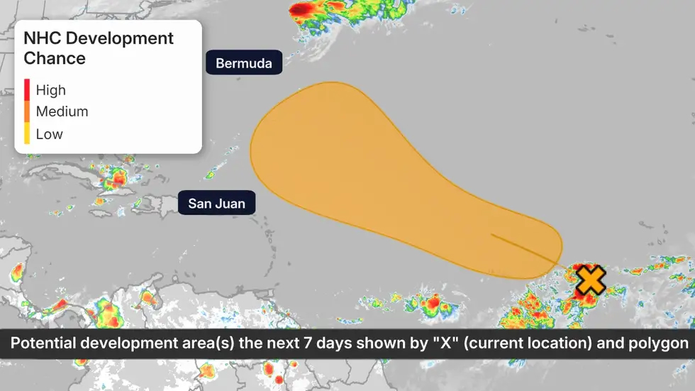 Tropical Development Potential
(The possible area(s) of tropical development according to the latest National Hurricane Center outlook are shown by polygons, color-coded by the chance of development over the next seven days. An "X" indicates the location of a current disturbance. Any active storms are shown by a tropical storm symbol and its corresponding forecast path. )
Farther east, a tropical wave has developed in the eastern Atlantic, currently producing scattered and disorganized showers.
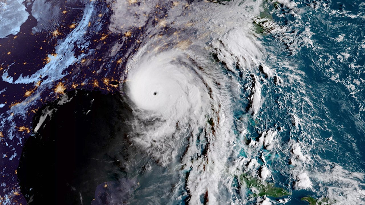
Dexter was briefly designated as a tropical storm late Sunday after forming from a stalled frontal boundary between Bermuda and North Carolina's Outer Banks.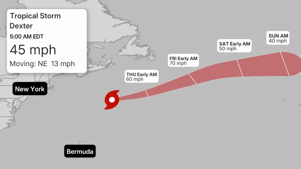 Tropical Development Potential
(The possible area(s) of tropical development according to the latest National Hurricane Center outlook are shown by polygons, color-coded by the chance of development over the next seven days. An "X" indicates the location of a current disturbance. Any active storms are shown by a tropical storm symbol and its corresponding forecast path. )At present, no strong indications of immediate tropical formation exist in this region, but conditions could change rapidly.Atlantic Activity Expected to Increase
The tropical Atlantic remains primed for further storm development:
With the heart of hurricane season approaching, experts emphasize the importance of readiness:
Meteorologists expect a new area of low pressure to form along a lingering stationary front just off the Southeast U.S. coast within the next 24–48 hours.
Tropical Development Potential(The possible area(s) of tropical development according to the latest National Hurricane Center outlook are shown by polygons, color-coded by the chance of development over the next seven days. An "X" indicates the location of a current disturbance. Any active storms are shown by a tropical storm symbol and its corresponding forecast path. )
- Potential Development: The system could slowly track northward before turning northeastward and heading back out to sea. If thunderstorms organize enough, it may become a tropical depression or even a named storm by late week or over the weekend.
- Possible Impacts: Regardless of whether it strengthens into a storm, this low could bring periods of heavy rain and thunderstorms to coastal regions from Georgia to the Carolinas and northern Florida.
- Marine Hazards: High surf and dangerous rip currents may develop along much of the East Coast, especially between North Carolina and the Delmarva Peninsula, from late week into the weekend.
Farther east, a tropical wave has developed in the eastern Atlantic, currently producing scattered and disorganized showers.
- Obstacles and Development Chances: Initially, the wave faces patches of dry air that could limit its growth. However, by the weekend, it may organize into a tropical depression or storm well east of the Lesser Antilles.
- Forecast Scenarios:
Dexter was briefly designated as a tropical storm late Sunday after forming from a stalled frontal boundary between Bermuda and North Carolina's Outer Banks.
- The storm is now moving further into the North Atlantic and is expected to lose its tropical characteristics by Thursday or sooner.
- Dexter does not pose a threat to the U.S. as it transitions into a non-tropical system.
Tropical Development Potential(The possible area(s) of tropical development according to the latest National Hurricane Center outlook are shown by polygons, color-coded by the chance of development over the next seven days. An "X" indicates the location of a current disturbance. Any active storms are shown by a tropical storm symbol and its corresponding forecast path. )At present, no strong indications of immediate tropical formation exist in this region, but conditions could change rapidly.Atlantic Activity Expected to Increase
The tropical Atlantic remains primed for further storm development:
- Warm ocean waters, reduced wind shear, and increased atmospheric moisture are creating favorable conditions for cyclones.
- Multiple tropical waves will continue rolling off the African coast in the coming weeks, one or more of which could become named storms.
- Historically, tropical activity accelerates significantly during the next 4–6 weeks, affecting areas from the Gulf of Mexico and Caribbean to the central and western Atlantic.
With the heart of hurricane season approaching, experts emphasize the importance of readiness:
- Review and update hurricane preparedness plans now, rather than waiting for an active storm threat.
- Stock essential supplies, check evacuation routes, and stay informed with official weather updates from the NHC.