
TIMING:
Rain will begin late Wednesday evening between 8 and 10 p.m., moving west to east. It will transition to light, wet snow early Thursday morning, with minimal accumulation—generally under an inch.
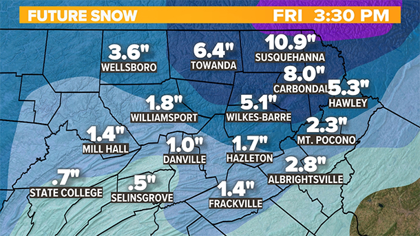
The main storm system will develop Thursday afternoon, bringing a mix of rain and snow showers before transitioning to primarily wet snow by the evening. Snowfall will continue steadily through Friday, tapering off late in the afternoon and evening.
IMPACT:
The heaviest snowfall is expected Thursday night into Friday, with accumulations mainly concentrated in areas north and east of Scranton, particularly those above 1,200 feet in elevation. Initially, warm ground temperatures will cause much of the snow to melt on roadways and sidewalks. However, as snowfall intensifies Friday, accumulations will begin to stick on grassy surfaces, secondary roads, and untreated areas. Travelers should prepare for potentially slick conditions as the day progresses.