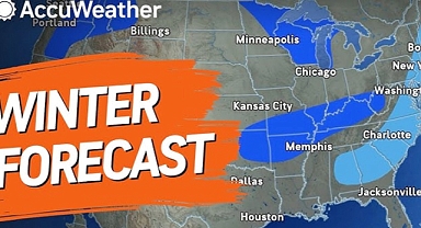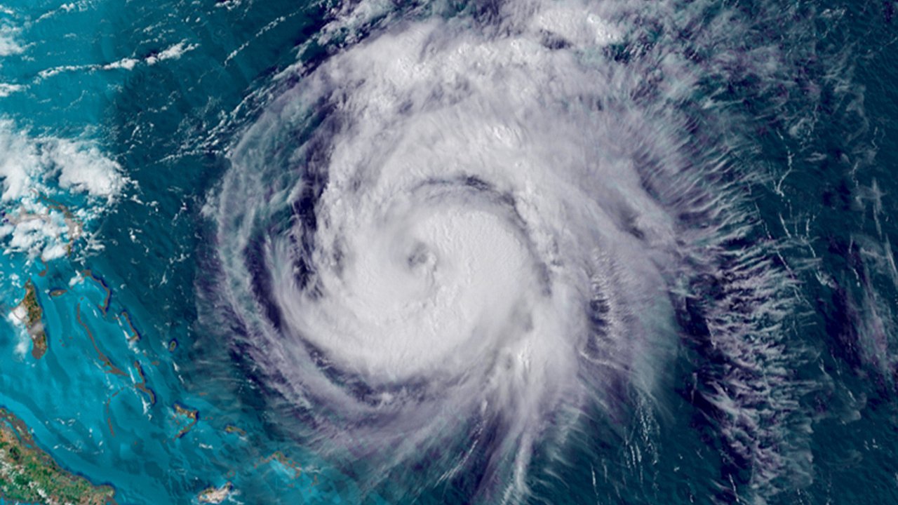
Tropical Storm Humberto is spinning in the west-central Atlantic Ocean, steadily intensifying as it tracks northwest. While it is not expected to directly strike the United States, forecasters warn it could rapidly strengthen into a major hurricane this weekend, posing a concern for Bermuda and shipping lanes. However, Humberto may not be the biggest threat in the tropics right now. Behind it, another disturbance known as Invest 94L is taking shape over the northern Caribbean, raising the possibility of Tropical Storm Imelda forming within days.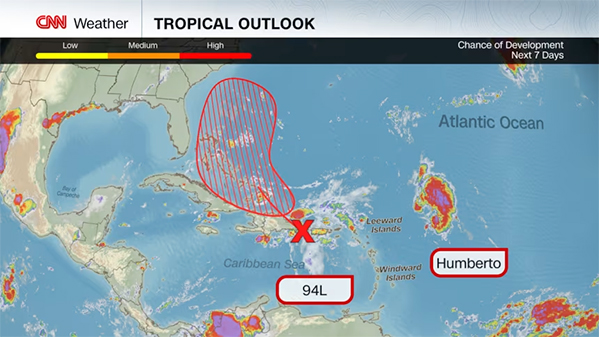 This developing system is already delivering torrential rain to Puerto Rico, the Virgin Islands, and Hispaniola, with risks of flash flooding and landslides. As it drifts toward the Bahamas this weekend, it will enter a more favorable environment for development, with forecasts pointing toward a tropical depression or storm. What happens next could determine the fate of millions along the US East Coast. The challenge lies in the complex interplay between Humberto, Invest 94L, and broader weather patterns over North America. If the systems align in just the right way, parts of the Southeast—especially the Carolinas—could face tropical storm or hurricane impacts as early as Monday.Humberto strengthens while staying offshoreHumberto is expected to continue moving northwest, remaining well to the west of Bermuda by early next week. Forecasters project that warm waters and low wind shear will allow it to intensify, potentially becoming a Category 3 hurricane. While the storm itself is unlikely to reach the United States, its size and circulation could still play a critical role in steering other tropical systems.A powerful hurricane in the western Atlantic can influence weaker storms nearby, tugging them into different paths or pulling them harmlessly away from land. This is one reason why meteorologists are carefully tracking the interaction between Humberto and Invest 94L in the days ahead.Invest 94L shows signs of developmentCurrently, Invest 94L is producing heavy rain across parts of the northern Caribbean. Communities in Puerto Rico, the Virgin Islands, and the mountainous regions of Hispaniola face flooding and landslide threats due to already saturated ground. The system remains disorganized, but conditions ahead—including warm ocean waters and reduced wind shear—make tropical development highly likely.If the disturbance organizes, it will likely be named Tropical Storm Imelda by the National Hurricane Center. Once it nears the Bahamas, the system will either curve out to sea, brush the East Coast, or potentially make landfall in the Southeast. The exact outcome depends on a complicated set of factors that are still unfolding.The Fujiwhara effect and storm interactionA major point of uncertainty comes from the possibility of storm interaction. When two tropical systems form near each other, they sometimes engage in what’s known as the Fujiwhara effect. In this rare phenomenon, the storms begin to rotate around a shared point, which can fling one storm harmlessly into the open ocean or push it closer to land.If Humberto remains dominant and Invest 94L is weaker, Humberto may steer the system northeast, sparing the US coast. But if Invest 94L strengthens quickly and gains momentum, it may resist Humberto’s influence, keeping its course toward the Southeast.The role of the jet streamAdding another layer of complexity is the jet stream pattern setting up across the United States. A dip in the jet stream along the East Coast could capture Invest 94L—or Imelda if it strengthens—and direct it closer to land. If Humberto drifts farther east, leaving more room for the jet stream to exert control, the chance of US landfall increases.The timing is also crucial. Forecasters suggest that any potential impact would arrive between Monday and Tuesday, with the Carolinas currently holding the highest probability of effects. However, other parts of the Southeast cannot be ruled out, and even regions farther north may experience heavy rainfall if tropical moisture surges inland.Possible impacts for the Southeast and mid-AtlanticShould Imelda track close to the coast, threats would include strong winds, storm surge along barrier islands, and widespread rainfall. Even if the system remains offshore, tropical moisture could stream into the Southeast and mid-Atlantic, fueling heavy rain and localized flooding next week. Coastal communities are urged to monitor updates closely, as the window for preparation may be short once the track becomes clearer.Forecast confidence remains lowMeteorologists emphasize that forecast confidence is lower than usual because of how many variables are at play. The strength, size, and timing of Humberto, combined with Invest 94L’s development and the evolving jet stream pattern, make this a particularly challenging scenario. Forecasters expect clearer guidance by Friday or Saturday, giving the Southeast only a narrow window to prepare if landfall becomes likely.For now, the Atlantic hurricane season continues to demonstrate its unpredictability. Whether the outcome is a brush, a strike, or a miss, the one certainty is that the forecast will keep shifting as Humberto and Invest 94L move into the weekend.
This developing system is already delivering torrential rain to Puerto Rico, the Virgin Islands, and Hispaniola, with risks of flash flooding and landslides. As it drifts toward the Bahamas this weekend, it will enter a more favorable environment for development, with forecasts pointing toward a tropical depression or storm. What happens next could determine the fate of millions along the US East Coast. The challenge lies in the complex interplay between Humberto, Invest 94L, and broader weather patterns over North America. If the systems align in just the right way, parts of the Southeast—especially the Carolinas—could face tropical storm or hurricane impacts as early as Monday.Humberto strengthens while staying offshoreHumberto is expected to continue moving northwest, remaining well to the west of Bermuda by early next week. Forecasters project that warm waters and low wind shear will allow it to intensify, potentially becoming a Category 3 hurricane. While the storm itself is unlikely to reach the United States, its size and circulation could still play a critical role in steering other tropical systems.A powerful hurricane in the western Atlantic can influence weaker storms nearby, tugging them into different paths or pulling them harmlessly away from land. This is one reason why meteorologists are carefully tracking the interaction between Humberto and Invest 94L in the days ahead.Invest 94L shows signs of developmentCurrently, Invest 94L is producing heavy rain across parts of the northern Caribbean. Communities in Puerto Rico, the Virgin Islands, and the mountainous regions of Hispaniola face flooding and landslide threats due to already saturated ground. The system remains disorganized, but conditions ahead—including warm ocean waters and reduced wind shear—make tropical development highly likely.If the disturbance organizes, it will likely be named Tropical Storm Imelda by the National Hurricane Center. Once it nears the Bahamas, the system will either curve out to sea, brush the East Coast, or potentially make landfall in the Southeast. The exact outcome depends on a complicated set of factors that are still unfolding.The Fujiwhara effect and storm interactionA major point of uncertainty comes from the possibility of storm interaction. When two tropical systems form near each other, they sometimes engage in what’s known as the Fujiwhara effect. In this rare phenomenon, the storms begin to rotate around a shared point, which can fling one storm harmlessly into the open ocean or push it closer to land.If Humberto remains dominant and Invest 94L is weaker, Humberto may steer the system northeast, sparing the US coast. But if Invest 94L strengthens quickly and gains momentum, it may resist Humberto’s influence, keeping its course toward the Southeast.The role of the jet streamAdding another layer of complexity is the jet stream pattern setting up across the United States. A dip in the jet stream along the East Coast could capture Invest 94L—or Imelda if it strengthens—and direct it closer to land. If Humberto drifts farther east, leaving more room for the jet stream to exert control, the chance of US landfall increases.The timing is also crucial. Forecasters suggest that any potential impact would arrive between Monday and Tuesday, with the Carolinas currently holding the highest probability of effects. However, other parts of the Southeast cannot be ruled out, and even regions farther north may experience heavy rainfall if tropical moisture surges inland.Possible impacts for the Southeast and mid-AtlanticShould Imelda track close to the coast, threats would include strong winds, storm surge along barrier islands, and widespread rainfall. Even if the system remains offshore, tropical moisture could stream into the Southeast and mid-Atlantic, fueling heavy rain and localized flooding next week. Coastal communities are urged to monitor updates closely, as the window for preparation may be short once the track becomes clearer.Forecast confidence remains lowMeteorologists emphasize that forecast confidence is lower than usual because of how many variables are at play. The strength, size, and timing of Humberto, combined with Invest 94L’s development and the evolving jet stream pattern, make this a particularly challenging scenario. Forecasters expect clearer guidance by Friday or Saturday, giving the Southeast only a narrow window to prepare if landfall becomes likely.For now, the Atlantic hurricane season continues to demonstrate its unpredictability. Whether the outcome is a brush, a strike, or a miss, the one certainty is that the forecast will keep shifting as Humberto and Invest 94L move into the weekend.