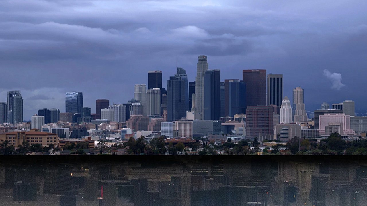
Los Angeles faces rare early-season atmospheric river storm
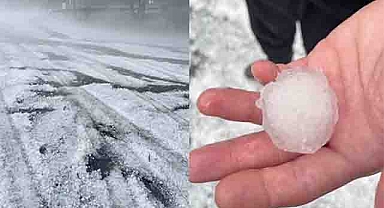
Los Angeles is preparing for a rare and powerful weather event that could deliver an entire month’s worth of rain in just a few days. According to the National Weather Service (NWS), a “significant” atmospheric river is forecast to hit Southern California later this week, bringing widespread rainfall, flash flooding risks, and potentially dangerous conditions in fire-scarred areas.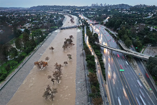 This atmospheric river—essentially a massive conveyor belt of moisture streaming from the Pacific Ocean—is expected to unleash between one and two inches of rain across much of California, with some areas seeing over three inches. Los Angeles alone could receive around 1.3 inches, nearly matching its average November rainfall total. Forecasters warn that this system may linger longer than usual, increasing the potential for flooding and infrastructure strain.While atmospheric rivers are not uncommon during California’s winter months, this storm stands out for its early arrival and intensity. November is typically a transitional month before the state’s wettest period, which usually occurs between December and February. Experts say this event could effectively mark an early end to Southern California’s fire season.What is an atmospheric river and why it matters
An atmospheric river is a narrow corridor of concentrated moisture that carries vast amounts of water vapor through the sky, often stretching thousands of miles. When this vapor reaches land, it condenses and releases heavy rain or snow. The National Oceanic and Atmospheric Administration (NOAA) describes these systems as “rivers in the sky” because they can transport more water than the Amazon River at any given time.These storms are a double-edged sword for California. On one hand, they are essential for replenishing reservoirs and snowpack that support the state’s water supply. On the other, they can trigger devastating floods, mudslides, and power outages—especially in urban and mountainous regions where drainage is limited.Forecast and potential impacts across Southern California
The NWS forecast indicates that rain will first hit San Luis Obispo and Santa Barbara counties on Thursday before moving south into Los Angeles by Friday. Thunderstorms and heavy downpours may persist into Saturday as the system slows and stalls offshore, creating a prolonged period of wet weather.Forecasters are particularly concerned about flash flooding, especially in areas recently affected by wildfires. Burn scars can’t absorb water efficiently, causing rain to flow rapidly downhill and potentially inundate roads and neighborhoods. The NWS has warned that “scattered to isolated flash flooding will also be possible as far south as the Los Angeles metro area.”The city’s low-lying and coastal neighborhoods may experience urban flooding, while mountain communities could see heavier rainfall totals exceeding three inches. Residents are urged to prepare for power outages, travel disruptions, and possible mudslides along hillsides weakened by previous fires.Experts and weather watchers weigh in
Bob Oravec, lead forecaster at the NWS Weather Prediction Center, explained that receiving an entire month’s worth of rain in a single event is “anomalous, but not unheard of” for Los Angeles. “Especially across an area that has a large standard deviation year to year with respect to precipitation,” he said. “The average doesn’t necessarily reflect what they typically get.”Extreme weather tracker Colin McCarthy echoed the concern, posting on X (formerly Twitter) that rainfall amounts “have dramatically increased to 1.5–3 inches for Southern California this weekend.” He noted that the prolonged storm would “end fire season across the region” as the system “slows down over SoCal as a cut-off low stalls offshore.”The NWS Weather Prediction Center also issued a statement on X, saying, “A slow-moving atmospheric river and upper low will bring threats of heavy rainfall to California. The threat will persist over a couple of days as the system may slow down across the region, particularly over portions of Southern California.”What comes next for Los Angeles
Rainfall is expected to taper off gradually by late Saturday, but forecasters caution that conditions could shift as the system develops. Residents should stay updated with NWS alerts, avoid flooded roadways, and prepare emergency supplies in case of prolonged power outages.If the forecasts hold, this atmospheric river will not only deliver much-needed precipitation but also highlight California’s increasing vulnerability to extreme weather swings—an unsettling pattern in an era of changing climate dynamics. For Los Angeles, this storm is both a reminder and a warning: in a region built on sun and drought, even a few days of rain can transform the landscape overnight.
Los Angeles is preparing for a rare and powerful weather event that could deliver an entire month’s worth of rain in just a few days. According to the National Weather Service (NWS), a “significant” atmospheric river is forecast to hit Southern California later this week, bringing widespread rainfall, flash flooding risks, and potentially dangerous conditions in fire-scarred areas.
This atmospheric river—essentially a massive conveyor belt of moisture streaming from the Pacific Ocean—is expected to unleash between one and two inches of rain across much of California, with some areas seeing over three inches. Los Angeles alone could receive around 1.3 inches, nearly matching its average November rainfall total. Forecasters warn that this system may linger longer than usual, increasing the potential for flooding and infrastructure strain.While atmospheric rivers are not uncommon during California’s winter months, this storm stands out for its early arrival and intensity. November is typically a transitional month before the state’s wettest period, which usually occurs between December and February. Experts say this event could effectively mark an early end to Southern California’s fire season.What is an atmospheric river and why it mattersAn atmospheric river is a narrow corridor of concentrated moisture that carries vast amounts of water vapor through the sky, often stretching thousands of miles. When this vapor reaches land, it condenses and releases heavy rain or snow. The National Oceanic and Atmospheric Administration (NOAA) describes these systems as “rivers in the sky” because they can transport more water than the Amazon River at any given time.These storms are a double-edged sword for California. On one hand, they are essential for replenishing reservoirs and snowpack that support the state’s water supply. On the other, they can trigger devastating floods, mudslides, and power outages—especially in urban and mountainous regions where drainage is limited.Forecast and potential impacts across Southern California
The NWS forecast indicates that rain will first hit San Luis Obispo and Santa Barbara counties on Thursday before moving south into Los Angeles by Friday. Thunderstorms and heavy downpours may persist into Saturday as the system slows and stalls offshore, creating a prolonged period of wet weather.Forecasters are particularly concerned about flash flooding, especially in areas recently affected by wildfires. Burn scars can’t absorb water efficiently, causing rain to flow rapidly downhill and potentially inundate roads and neighborhoods. The NWS has warned that “scattered to isolated flash flooding will also be possible as far south as the Los Angeles metro area.”The city’s low-lying and coastal neighborhoods may experience urban flooding, while mountain communities could see heavier rainfall totals exceeding three inches. Residents are urged to prepare for power outages, travel disruptions, and possible mudslides along hillsides weakened by previous fires.Experts and weather watchers weigh in
Bob Oravec, lead forecaster at the NWS Weather Prediction Center, explained that receiving an entire month’s worth of rain in a single event is “anomalous, but not unheard of” for Los Angeles. “Especially across an area that has a large standard deviation year to year with respect to precipitation,” he said. “The average doesn’t necessarily reflect what they typically get.”Extreme weather tracker Colin McCarthy echoed the concern, posting on X (formerly Twitter) that rainfall amounts “have dramatically increased to 1.5–3 inches for Southern California this weekend.” He noted that the prolonged storm would “end fire season across the region” as the system “slows down over SoCal as a cut-off low stalls offshore.”The NWS Weather Prediction Center also issued a statement on X, saying, “A slow-moving atmospheric river and upper low will bring threats of heavy rainfall to California. The threat will persist over a couple of days as the system may slow down across the region, particularly over portions of Southern California.”What comes next for Los Angeles
Rainfall is expected to taper off gradually by late Saturday, but forecasters caution that conditions could shift as the system develops. Residents should stay updated with NWS alerts, avoid flooded roadways, and prepare emergency supplies in case of prolonged power outages.If the forecasts hold, this atmospheric river will not only deliver much-needed precipitation but also highlight California’s increasing vulnerability to extreme weather swings—an unsettling pattern in an era of changing climate dynamics. For Los Angeles, this storm is both a reminder and a warning: in a region built on sun and drought, even a few days of rain can transform the landscape overnight.