California weather to take a sharp turn
Southern California’s usually mild late autumn is about to get turbulent. Meteorologists warn of strong gusty winds and fluctuating temperatures that will bring an unpredictable few days to the region. The National Weather Service (NWS) predicts that winds could reach up to 50–55 mph across parts of San Diego County and the San Gorgonio Pass near Banning. For residents accustomed to pleasant, sunny days, this week’s rollercoaster weather is expected to bring a taste of winter’s volatility.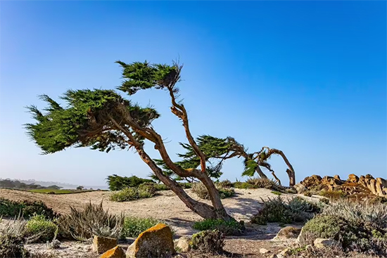 The gusts are expected to intensify through the weekend, ushering in cooler air and dropping temperatures several degrees below the seasonal average. However, this will not last long — forecasters expect another shift early next week as dry and warmer weather returns to the area. Californians may find themselves switching from jackets to T-shirts in a matter of days as the state experiences these contrasting conditions.Gusty winds to sweep across Southern California
According to the NWS, west winds will strengthen to 25–35 mph across San Diego County, with gusts topping 50 mph in certain areas. The strongest winds are expected through mountain passes, especially the San Gorgonio Pass, where gusts could hit 55 mph. These winds pose potential hazards, including downed branches, dust storms, and driving difficulties, particularly for high-profile vehicles on highways.Forecasters also warn that the gusty conditions may return midweek, with a weak offshore flow developing by Tuesday and Wednesday. This pattern could produce locally strong northeast-to-east winds along the coastal mountain slopes and valleys — a typical setup for Santa Ana winds.Residents are urged to secure outdoor items, clear any loose debris, and prepare for potential power interruptions. Those living near wildfire-prone areas are also advised to remain vigilant, as dry, windy conditions can increase fire risks even during cooler months.Temperature drop to bring cooler weekend weatherA noticeable dip in temperatures will accompany the strong winds. According to NWS San Diego, the weekend will bring cooler conditions, with daytime highs expected to fall three to five degrees below normal, especially on Sunday. While inland areas may cool more sharply, coastal regions will also feel the chill, particularly during the evenings and early mornings.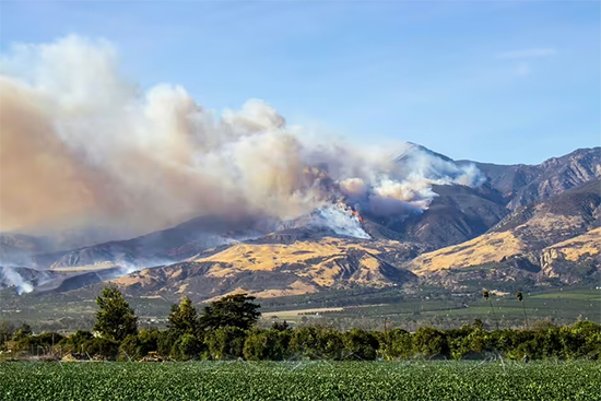 The Area Forecast Discussion suggests that by early next week, temperatures will rebound as high pressure builds over the state. Inland regions could see highs rise up to five degrees above the seasonal average by midweek. This back-and-forth pattern — typical for Southern California’s transitional seasons — underscores how quickly the region’s weather can swing from cool and breezy to warm and dry.NOAA outlook: Mild but dry winter aheadLooking further ahead, the National Oceanic and Atmospheric Administration (NOAA) expects Southern California to experience a mild but dry winter. Its Climate Prediction Center’s seasonal outlook shows that while the Upper Midwest and Pacific Northwest will likely endure cooler-than-average conditions, the southern and eastern parts of the United States — including California — are more likely to see warmer, drier weather.This outlook raises concerns about limited rainfall and an increased risk of wildfires, especially if Santa Ana winds remain active during the peak of their season. Dry vegetation, combined with periodic gusty winds, can quickly escalate fire danger across Southern California.Experts recommend homeowners begin preparing now by maintaining defensible space around their properties, trimming trees, and removing flammable materials. While the winter may feel mild compared to other regions, the potential for strong wind events means residents must stay alert and ready for sudden changes.Santa Ana winds and wildfire preparednessThe Santa Ana wind season typically peaks during winter, and meteorologists caution that these powerful offshore winds may return in the coming weeks. Characterized by their dry, warm nature, Santa Ana winds can rapidly intensify wildfires by spreading flames across dry brush and steep terrain.Officials advise Californians to prepare early by clearing debris from around homes, keeping emergency kits ready, and monitoring local forecasts. The combination of dry air, gusty winds, and fluctuating temperatures can create challenging conditions even for short periods.As Southern California braces for a volatile stretch of weather — swinging from cold, windy days to warmer, dry conditions — residents are reminded that preparation is key. While the coming winter may bring fewer storms, it will likely test the state’s resilience to wind and fire once again.
Southern California’s usually mild late autumn is about to get turbulent. Meteorologists warn of strong gusty winds and fluctuating temperatures that will bring an unpredictable few days to the region. The National Weather Service (NWS) predicts that winds could reach up to 50–55 mph across parts of San Diego County and the San Gorgonio Pass near Banning. For residents accustomed to pleasant, sunny days, this week’s rollercoaster weather is expected to bring a taste of winter’s volatility.
The gusts are expected to intensify through the weekend, ushering in cooler air and dropping temperatures several degrees below the seasonal average. However, this will not last long — forecasters expect another shift early next week as dry and warmer weather returns to the area. Californians may find themselves switching from jackets to T-shirts in a matter of days as the state experiences these contrasting conditions.Gusty winds to sweep across Southern CaliforniaAccording to the NWS, west winds will strengthen to 25–35 mph across San Diego County, with gusts topping 50 mph in certain areas. The strongest winds are expected through mountain passes, especially the San Gorgonio Pass, where gusts could hit 55 mph. These winds pose potential hazards, including downed branches, dust storms, and driving difficulties, particularly for high-profile vehicles on highways.Forecasters also warn that the gusty conditions may return midweek, with a weak offshore flow developing by Tuesday and Wednesday. This pattern could produce locally strong northeast-to-east winds along the coastal mountain slopes and valleys — a typical setup for Santa Ana winds.Residents are urged to secure outdoor items, clear any loose debris, and prepare for potential power interruptions. Those living near wildfire-prone areas are also advised to remain vigilant, as dry, windy conditions can increase fire risks even during cooler months.Temperature drop to bring cooler weekend weatherA noticeable dip in temperatures will accompany the strong winds. According to NWS San Diego, the weekend will bring cooler conditions, with daytime highs expected to fall three to five degrees below normal, especially on Sunday. While inland areas may cool more sharply, coastal regions will also feel the chill, particularly during the evenings and early mornings.
The Area Forecast Discussion suggests that by early next week, temperatures will rebound as high pressure builds over the state. Inland regions could see highs rise up to five degrees above the seasonal average by midweek. This back-and-forth pattern — typical for Southern California’s transitional seasons — underscores how quickly the region’s weather can swing from cool and breezy to warm and dry.NOAA outlook: Mild but dry winter aheadLooking further ahead, the National Oceanic and Atmospheric Administration (NOAA) expects Southern California to experience a mild but dry winter. Its Climate Prediction Center’s seasonal outlook shows that while the Upper Midwest and Pacific Northwest will likely endure cooler-than-average conditions, the southern and eastern parts of the United States — including California — are more likely to see warmer, drier weather.This outlook raises concerns about limited rainfall and an increased risk of wildfires, especially if Santa Ana winds remain active during the peak of their season. Dry vegetation, combined with periodic gusty winds, can quickly escalate fire danger across Southern California.Experts recommend homeowners begin preparing now by maintaining defensible space around their properties, trimming trees, and removing flammable materials. While the winter may feel mild compared to other regions, the potential for strong wind events means residents must stay alert and ready for sudden changes.Santa Ana winds and wildfire preparednessThe Santa Ana wind season typically peaks during winter, and meteorologists caution that these powerful offshore winds may return in the coming weeks. Characterized by their dry, warm nature, Santa Ana winds can rapidly intensify wildfires by spreading flames across dry brush and steep terrain.Officials advise Californians to prepare early by clearing debris from around homes, keeping emergency kits ready, and monitoring local forecasts. The combination of dry air, gusty winds, and fluctuating temperatures can create challenging conditions even for short periods.As Southern California braces for a volatile stretch of weather — swinging from cold, windy days to warmer, dry conditions — residents are reminded that preparation is key. While the coming winter may bring fewer storms, it will likely test the state’s resilience to wind and fire once again.