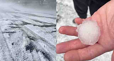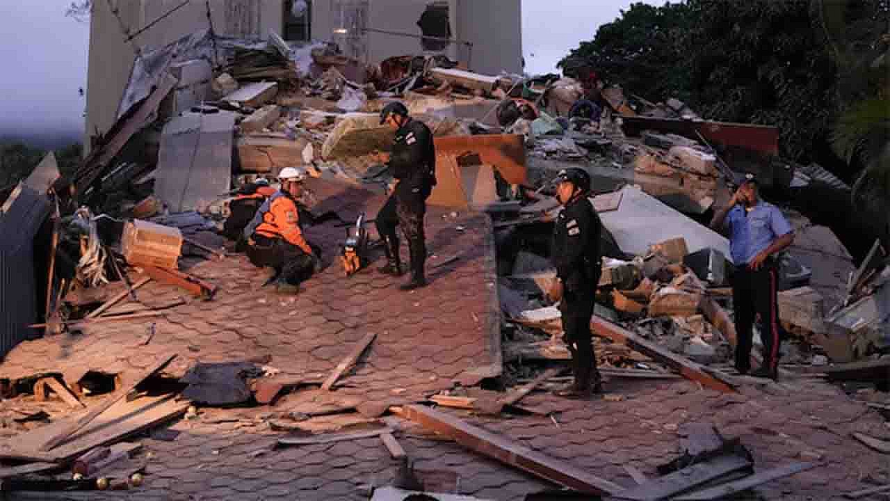
A rare and powerful seismic event captured global attention when two major earthquakes struck Venezuela only 39 seconds apart. The first earthquake registered a magnitude of 7.1, followed almost immediately by a stronger magnitude 7.5 tremor. The intense shaking was felt across northern Venezuela, including Caracas, while tsunami alerts were issued in parts of the Caribbean as authorities monitored the situation closely.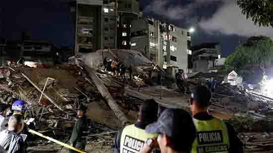 Events of this scale are uncommon, but what makes this incident especially remarkable is the extremely short interval between the two earthquakes. Scientists often refer to such occurrences as an earthquake doublet, a phenomenon in which two significant seismic events happen in rapid succession within the same region. As emergency teams assess potential damage and monitor aftershocks, geologists are also studying the event to better understand the tectonic forces responsible. This earthquake sequence highlights the dynamic geological environment of the Caribbean and serves as a reminder of the powerful natural processes constantly reshaping the Earth's crust.What happened in Venezuela?The seismic sequence began with a magnitude 7.1 earthquake that struck northern Venezuela. Just 39 seconds later, a second and even stronger magnitude 7.5 earthquake occurred in the same general region. The close timing of the events created prolonged shaking that was felt across a wide area.
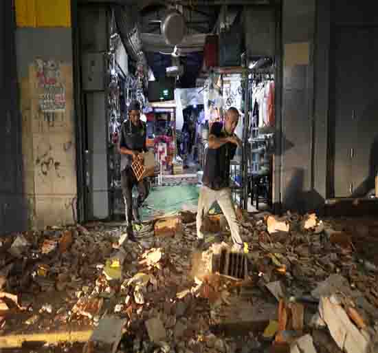 Residents in Caracas reported noticeable ground movement, while people in neighboring regions experienced strong tremors. Due to the magnitude of the earthquakes and their proximity to coastal areas, tsunami alerts were issued for parts of the Caribbean as a precautionary measure.Authorities quickly began evaluating infrastructure, transportation networks, communication systems, and coastal communities. While aftershocks are expected following major seismic events, the unusual doublet nature of the earthquakes has drawn additional attention from the scientific community.Why earthquake doublets are unusualMost large earthquakes are followed by smaller aftershocks that gradually decrease in intensity over time. An earthquake doublet differs because two major earthquakes of comparable strength occur within a very short period.
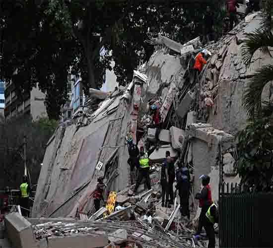 The Venezuela earthquake sequence fits this description due to the significant magnitudes of both events and the brief 39-second interval separating them. Such occurrences are relatively rare and can increase the overall impact on affected regions.When a large earthquake occurs, stress is redistributed throughout surrounding fault systems. In some cases, this stress transfer may trigger another major rupture almost immediately. Understanding these processes is important for improving seismic hazard assessments and earthquake forecasting models.Scientists will likely spend months analyzing seismic data from this event to determine whether the second earthquake was triggered directly by the first or whether both resulted from a broader fault rupture process.Understanding Caribbean tectonicsThe Caribbean region sits within one of the world's most geologically active zones. Several tectonic plates interact throughout the area, including the Caribbean Plate, the South American Plate, the North American Plate, and the Cocos Plate.Venezuela lies near the boundary between the Caribbean Plate and the South American Plate. These massive sections of Earth's crust are constantly moving, although their motion is usually measured in only a few centimeters per year.Over time, stress accumulates along fault lines as the plates push, pull, and slide past one another. When the accumulated stress exceeds the strength of the rocks, the fault ruptures and releases energy in the form of seismic waves, producing an earthquake.This ongoing tectonic activity explains why earthquakes remain a persistent natural hazard throughout Venezuela and the wider Caribbean region.How tsunami alerts are triggeredWhenever a powerful earthquake occurs near the ocean, scientists must quickly determine whether it has the potential to generate a tsunami. The risk depends on several factors, including earthquake magnitude, depth, and the type of fault movement involved.
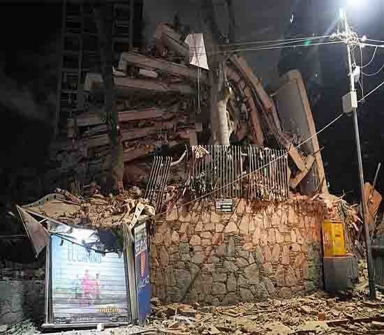 Large undersea earthquakes can displace enormous volumes of water, creating waves that travel across entire ocean basins. Because tsunami waves can reach coastlines within minutes to hours, emergency agencies often issue alerts as a precaution while additional data is collected.Following the Venezuela earthquakes, tsunami monitoring centers evaluated seismic information and sea-level measurements to assess any potential threat to Caribbean coastlines. These early warnings play a critical role in protecting coastal populations and reducing the risk of casualties.Potential impacts of a magnitude 7.5 earthquakeA magnitude 7.5 earthquake is considered a major seismic event capable of causing significant damage, particularly if it occurs near populated areas. Buildings, bridges, roads, and utility systems can be affected by intense ground shaking.The impact of an earthquake depends on several factors, including population density, construction quality, soil conditions, and earthquake depth. Even regions located hundreds of kilometers away may experience noticeable shaking during an event of this magnitude.In addition to structural damage, secondary hazards can occur. These may include landslides, liquefaction, coastal flooding, and disruptions to transportation and communication networks. Emergency management agencies typically remain on high alert following major earthquakes because aftershocks can continue for days, weeks, or even months.What scientists will study nextSeismologists around the world are expected to closely examine data from this earthquake doublet. Advanced seismic networks record the movement of seismic waves in extraordinary detail, allowing researchers to reconstruct the rupture process.Scientists will investigate the relationship between the magnitude 7.1 earthquake and the magnitude 7.5 earthquake to determine how stress moved through the fault system. They will also analyze aftershock patterns, fault geometry, and ground deformation measurements collected from satellites and GPS instruments.These findings may contribute valuable insights into earthquake behavior in complex tectonic environments and improve understanding of seismic hazards throughout the Caribbean.Why this event mattersThe powerful Venezuela earthquake doublet serves as a reminder that Earth's tectonic forces are continuously active beneath our feet. Two major earthquakes occurring only 39 seconds apart is an extraordinary event that demonstrates how rapidly geological processes can unfold.As emergency officials continue assessing conditions and monitoring aftershocks, scientists are gaining a rare opportunity to study one of the most unusual seismic sequences in recent years. The earthquakes highlight the importance of preparedness, early warning systems, and ongoing research in regions vulnerable to seismic activity.For residents of Venezuela, Caracas, and surrounding Caribbean communities, the event underscores the reality of living within an active tectonic zone where powerful natural forces continue to shape the landscape. Understanding these processes not only helps improve public safety but also reveals the fascinating geological patterns that often remain hidden in plain sight.
Events of this scale are uncommon, but what makes this incident especially remarkable is the extremely short interval between the two earthquakes. Scientists often refer to such occurrences as an earthquake doublet, a phenomenon in which two significant seismic events happen in rapid succession within the same region. As emergency teams assess potential damage and monitor aftershocks, geologists are also studying the event to better understand the tectonic forces responsible. This earthquake sequence highlights the dynamic geological environment of the Caribbean and serves as a reminder of the powerful natural processes constantly reshaping the Earth's crust.What happened in Venezuela?The seismic sequence began with a magnitude 7.1 earthquake that struck northern Venezuela. Just 39 seconds later, a second and even stronger magnitude 7.5 earthquake occurred in the same general region. The close timing of the events created prolonged shaking that was felt across a wide area.Residents in Caracas reported noticeable ground movement, while people in neighboring regions experienced strong tremors. Due to the magnitude of the earthquakes and their proximity to coastal areas, tsunami alerts were issued for parts of the Caribbean as a precautionary measure.Authorities quickly began evaluating infrastructure, transportation networks, communication systems, and coastal communities. While aftershocks are expected following major seismic events, the unusual doublet nature of the earthquakes has drawn additional attention from the scientific community.Why earthquake doublets are unusualMost large earthquakes are followed by smaller aftershocks that gradually decrease in intensity over time. An earthquake doublet differs because two major earthquakes of comparable strength occur within a very short period.The Venezuela earthquake sequence fits this description due to the significant magnitudes of both events and the brief 39-second interval separating them. Such occurrences are relatively rare and can increase the overall impact on affected regions.When a large earthquake occurs, stress is redistributed throughout surrounding fault systems. In some cases, this stress transfer may trigger another major rupture almost immediately. Understanding these processes is important for improving seismic hazard assessments and earthquake forecasting models.Scientists will likely spend months analyzing seismic data from this event to determine whether the second earthquake was triggered directly by the first or whether both resulted from a broader fault rupture process.Understanding Caribbean tectonicsThe Caribbean region sits within one of the world's most geologically active zones. Several tectonic plates interact throughout the area, including the Caribbean Plate, the South American Plate, the North American Plate, and the Cocos Plate.Venezuela lies near the boundary between the Caribbean Plate and the South American Plate. These massive sections of Earth's crust are constantly moving, although their motion is usually measured in only a few centimeters per year.Over time, stress accumulates along fault lines as the plates push, pull, and slide past one another. When the accumulated stress exceeds the strength of the rocks, the fault ruptures and releases energy in the form of seismic waves, producing an earthquake.This ongoing tectonic activity explains why earthquakes remain a persistent natural hazard throughout Venezuela and the wider Caribbean region.How tsunami alerts are triggeredWhenever a powerful earthquake occurs near the ocean, scientists must quickly determine whether it has the potential to generate a tsunami. The risk depends on several factors, including earthquake magnitude, depth, and the type of fault movement involved.Large undersea earthquakes can displace enormous volumes of water, creating waves that travel across entire ocean basins. Because tsunami waves can reach coastlines within minutes to hours, emergency agencies often issue alerts as a precaution while additional data is collected.Following the Venezuela earthquakes, tsunami monitoring centers evaluated seismic information and sea-level measurements to assess any potential threat to Caribbean coastlines. These early warnings play a critical role in protecting coastal populations and reducing the risk of casualties.Potential impacts of a magnitude 7.5 earthquakeA magnitude 7.5 earthquake is considered a major seismic event capable of causing significant damage, particularly if it occurs near populated areas. Buildings, bridges, roads, and utility systems can be affected by intense ground shaking.The impact of an earthquake depends on several factors, including population density, construction quality, soil conditions, and earthquake depth. Even regions located hundreds of kilometers away may experience noticeable shaking during an event of this magnitude.In addition to structural damage, secondary hazards can occur. These may include landslides, liquefaction, coastal flooding, and disruptions to transportation and communication networks. Emergency management agencies typically remain on high alert following major earthquakes because aftershocks can continue for days, weeks, or even months.What scientists will study nextSeismologists around the world are expected to closely examine data from this earthquake doublet. Advanced seismic networks record the movement of seismic waves in extraordinary detail, allowing researchers to reconstruct the rupture process.Scientists will investigate the relationship between the magnitude 7.1 earthquake and the magnitude 7.5 earthquake to determine how stress moved through the fault system. They will also analyze aftershock patterns, fault geometry, and ground deformation measurements collected from satellites and GPS instruments.These findings may contribute valuable insights into earthquake behavior in complex tectonic environments and improve understanding of seismic hazards throughout the Caribbean.Why this event mattersThe powerful Venezuela earthquake doublet serves as a reminder that Earth's tectonic forces are continuously active beneath our feet. Two major earthquakes occurring only 39 seconds apart is an extraordinary event that demonstrates how rapidly geological processes can unfold.As emergency officials continue assessing conditions and monitoring aftershocks, scientists are gaining a rare opportunity to study one of the most unusual seismic sequences in recent years. The earthquakes highlight the importance of preparedness, early warning systems, and ongoing research in regions vulnerable to seismic activity.For residents of Venezuela, Caracas, and surrounding Caribbean communities, the event underscores the reality of living within an active tectonic zone where powerful natural forces continue to shape the landscape. Understanding these processes not only helps improve public safety but also reveals the fascinating geological patterns that often remain hidden in plain sight.