A storm that changed historyOn August 29, 2005, Hurricane Katrina became one of the most infamous natural disasters in American history. Striking the Gulf Coast with devastating force, Katrina claimed 1,392 lives, most of them in Louisiana and Mississippi. It also caused more than $125 billion in damage, making it the costliest U.S. hurricane at the time, tied only years later by Hurricane Harvey in 2017.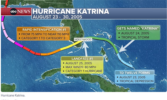 From its beginnings as a tropical wave to its peak as a monstrous Category 5 storm in the Gulf of Mexico, Katrina showcased the terrifying power of rapid intensification and the vulnerability of coastal cities. New Orleans, in particular, suffered catastrophic flooding due to levee and pump failures, while Mississippi’s coast endured historic storm surge levels. Nearly two decades later, Katrina’s path remains a sobering lesson in weather science, emergency preparedness, and the destructive force of nature.Katrina’s beginnings in the tropicsThe storm that would become Hurricane Katrina first appeared as a tropical wave on August 19, 2005, near the Lesser Antilles. As it merged with remnants of a previous tropical depression, the disturbance grew more organized while tracking northwest toward the Bahamas.
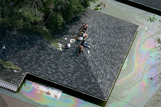 By August 23, the system strengthened into a tropical depression, and within 24 hours, it reached tropical storm status with sustained winds of 40 mph. At that moment, it was officially named Katrina.Katrina moved westward toward South Florida, intensifying into a hurricane just hours before making landfall on August 25 near Hollywood, Florida. With sustained winds of 80 mph, it caused flooding and power outages before weakening over the Everglades. By August 26, the storm reemerged in the Gulf of Mexico, poised to strengthen dramatically.Rapid intensification over the GulfOnce over the warm waters of the Gulf, Katrina began a period of rapid intensification. With unusually high sea surface temperatures and low wind shear, the storm had near-perfect conditions to strengthen.On August 26, Katrina’s winds jumped from 75 mph to nearly 110 mph in less than 24 hours, making it a strong Category 2 storm. The following day, after briefly weakening due to an eyewall replacement cycle, Katrina exploded in strength once again. By August 28, it reached Category 5 status with maximum sustained winds of 175 mph, becoming the strongest hurricane ever recorded in the Gulf of Mexico at that time.Although Katrina later weakened slightly before landfall, its massive wind field and storm surge potential made it a catastrophic threat to the Gulf Coast.Dire forecasts and urgent warningsAs Katrina barreled toward Louisiana and Mississippi, forecasters sounded unusually grim alarms. The National Weather Service office in New Orleans issued stark warnings on August 28, declaring that “most of the area will be uninhabitable for weeks…perhaps longer.” The advisory even warned of “certain death” for those caught outside during the storm, language rarely used in official forecasts.That same day, New Orleans Mayor Ray Nagin ordered the first-ever mandatory evacuation of the city. More than one million people across the region fled inland, though tens of thousands remained behind due to lack of transportation, finances, or willingness to leave.Katrina’s landfalls and destructionOn the morning of August 29, 2005, Katrina made its second landfall in Plaquemines Parish, Louisiana, as a Category 3 storm with winds of 125 mph. Its massive wind field extended nearly 120 miles from the center, bringing destructive gusts across much of the Gulf Coast.
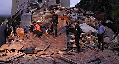
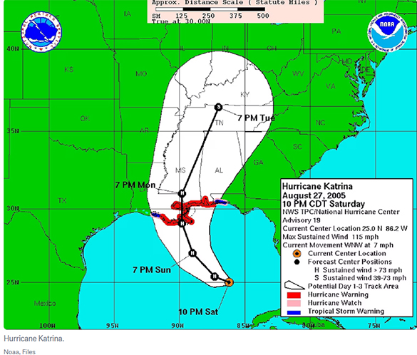 Later that morning, Katrina made its third landfall near the Louisiana-Mississippi border with winds of 120 mph. In New Orleans, levee failures allowed Lake Pontchartrain to pour into neighborhoods, submerging 80% of the city. In Mississippi, a record-setting storm surge destroyed entire coastal towns, leaving behind little more than concrete foundations.By the afternoon of August 29, Katrina had weakened to a tropical storm as it pushed inland, and by August 30, it was a tropical depression near Tennessee. On August 31, the storm dissipated entirely, but its devastation was only beginning to be understood.Katrina’s legacy and retirementThe World Meteorological Organization retired the name “Katrina” in 2006 due to the storm’s catastrophic impact. Its place in meteorological history is secured as a grim reminder of the dangers of rapid intensification and coastal vulnerability.
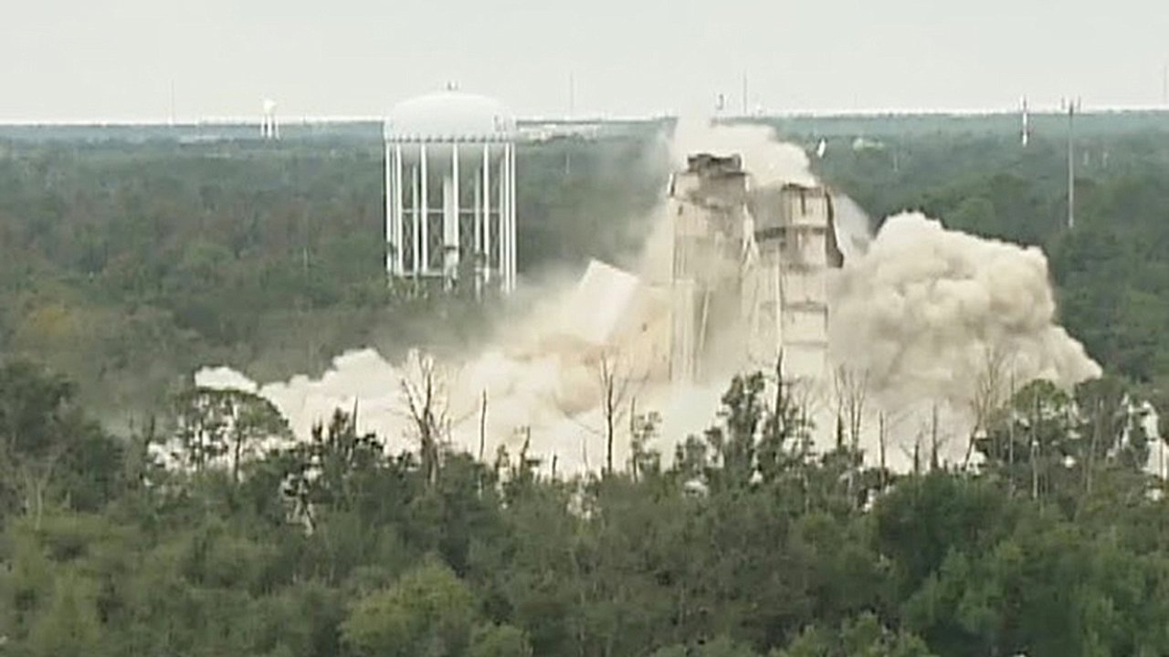
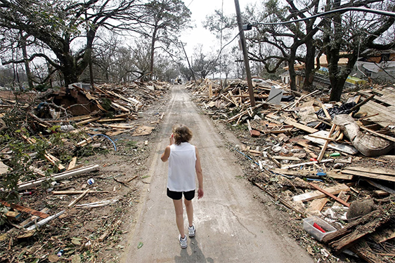 Nearly 20 years later, Hurricane Katrina remains a symbol of both natural disaster and human resilience. It reshaped emergency management practices, sparked debate over infrastructure and preparedness, and continues to influence how forecasters and communities respond to major hurricanes today.
From its beginnings as a tropical wave to its peak as a monstrous Category 5 storm in the Gulf of Mexico, Katrina showcased the terrifying power of rapid intensification and the vulnerability of coastal cities. New Orleans, in particular, suffered catastrophic flooding due to levee and pump failures, while Mississippi’s coast endured historic storm surge levels. Nearly two decades later, Katrina’s path remains a sobering lesson in weather science, emergency preparedness, and the destructive force of nature.Katrina’s beginnings in the tropicsThe storm that would become Hurricane Katrina first appeared as a tropical wave on August 19, 2005, near the Lesser Antilles. As it merged with remnants of a previous tropical depression, the disturbance grew more organized while tracking northwest toward the Bahamas.By August 23, the system strengthened into a tropical depression, and within 24 hours, it reached tropical storm status with sustained winds of 40 mph. At that moment, it was officially named Katrina.Katrina moved westward toward South Florida, intensifying into a hurricane just hours before making landfall on August 25 near Hollywood, Florida. With sustained winds of 80 mph, it caused flooding and power outages before weakening over the Everglades. By August 26, the storm reemerged in the Gulf of Mexico, poised to strengthen dramatically.Rapid intensification over the GulfOnce over the warm waters of the Gulf, Katrina began a period of rapid intensification. With unusually high sea surface temperatures and low wind shear, the storm had near-perfect conditions to strengthen.On August 26, Katrina’s winds jumped from 75 mph to nearly 110 mph in less than 24 hours, making it a strong Category 2 storm. The following day, after briefly weakening due to an eyewall replacement cycle, Katrina exploded in strength once again. By August 28, it reached Category 5 status with maximum sustained winds of 175 mph, becoming the strongest hurricane ever recorded in the Gulf of Mexico at that time.Although Katrina later weakened slightly before landfall, its massive wind field and storm surge potential made it a catastrophic threat to the Gulf Coast.Dire forecasts and urgent warningsAs Katrina barreled toward Louisiana and Mississippi, forecasters sounded unusually grim alarms. The National Weather Service office in New Orleans issued stark warnings on August 28, declaring that “most of the area will be uninhabitable for weeks…perhaps longer.” The advisory even warned of “certain death” for those caught outside during the storm, language rarely used in official forecasts.That same day, New Orleans Mayor Ray Nagin ordered the first-ever mandatory evacuation of the city. More than one million people across the region fled inland, though tens of thousands remained behind due to lack of transportation, finances, or willingness to leave.Katrina’s landfalls and destructionOn the morning of August 29, 2005, Katrina made its second landfall in Plaquemines Parish, Louisiana, as a Category 3 storm with winds of 125 mph. Its massive wind field extended nearly 120 miles from the center, bringing destructive gusts across much of the Gulf Coast.Later that morning, Katrina made its third landfall near the Louisiana-Mississippi border with winds of 120 mph. In New Orleans, levee failures allowed Lake Pontchartrain to pour into neighborhoods, submerging 80% of the city. In Mississippi, a record-setting storm surge destroyed entire coastal towns, leaving behind little more than concrete foundations.By the afternoon of August 29, Katrina had weakened to a tropical storm as it pushed inland, and by August 30, it was a tropical depression near Tennessee. On August 31, the storm dissipated entirely, but its devastation was only beginning to be understood.Katrina’s legacy and retirementThe World Meteorological Organization retired the name “Katrina” in 2006 due to the storm’s catastrophic impact. Its place in meteorological history is secured as a grim reminder of the dangers of rapid intensification and coastal vulnerability.Nearly 20 years later, Hurricane Katrina remains a symbol of both natural disaster and human resilience. It reshaped emergency management practices, sparked debate over infrastructure and preparedness, and continues to influence how forecasters and communities respond to major hurricanes today.