Dangerous Heat Wave Finally Breaks
But while temperatures are beginning to drop, the relief is arriving with a potentially dangerous side effect — a powerful storm front is sweeping into the area and bringing the threat of torrential rainfall and localized flooding.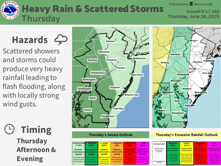 According to the National Weather Service (NWS), the arrival of the system on Thursday will mark the beginning of cooler, yet unstable weather conditions across eastern Pennsylvania and the surrounding areas.Storm Front Brings Risk of Heavy Rain and Flooding
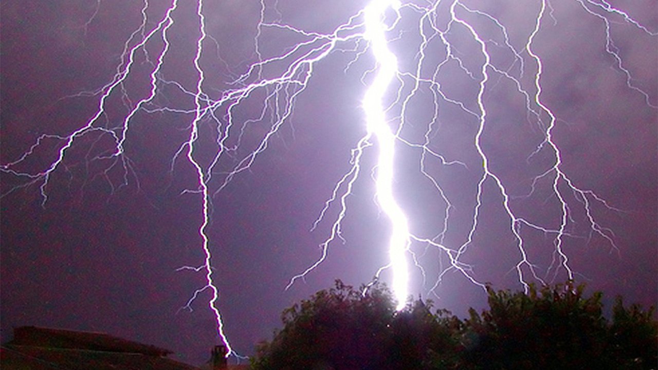
Rain and thunderstorms are forecast to begin after 2 p.m. Thursday, and while not everyone will experience the same effects, areas hit hardest by the system could see intense rainfall, wind gusts, and flash flooding. The NWS has placed much of eastern Pennsylvania under a "marginal" risk level for excessive rainfall and severe thunderstorms — meaning isolated flooding and damaging winds are possible.AccuWeather meteorologists emphasized that this "backdoor cold front" will usher in major changes. “It can dramatically drop temperatures by 20 to 40 degrees in some cases,” said Brett Anderson, Senior Meteorologist at AccuWeather. Such a significant drop is unusual for this time of year and could create sharply contrasting conditions across the region.Flash Flooding, High Winds, and Temperature Drops Expected
In addition to flash flood concerns, wind gusts may reach damaging levels in storm cells. Temperatures will be notably cooler in areas affected directly by the front, though regions with less rainfall may still experience oppressive humidity and high heat indexes. Forecasters noted the variability in local conditions will depend heavily on how the storm system develops throughout the day.The Mt. Holly, New Jersey office of the National Weather Service highlighted the uneven nature of the relief: “A backdoor cold front will be moving through today, providing relief to the heat for some, but not all.”Full Forecast: Cooler Temperatures with Continued Rain Threat
Thursday:
Scattered showers and thunderstorms likely after 2 p.m. Skies partly sunny, with a high near 90°F. Winds from the northeast around 10 mph. Chance of precipitation is 40%. Rainfall less than a tenth of an inch, but locally heavier in storms.Thursday Night:
Showers and thunderstorms possible, especially after 1 a.m. Mostly cloudy with a low around 66°F. Winds from the northeast at 10–15 mph. Chance of rain is 50%. Rainfall amounts between a tenth and quarter of an inch, higher in thunderstorms.Friday:
Mostly cloudy with a slight chance of showers before 2 p.m., then again after 3 p.m. High around 73°F with an east wind at 10 mph and gusts up to 20 mph. Chance of rain is 20%.Friday Night:
Cloudy with occasional showers and thunderstorms. Low near 68°F. Light east wind becoming calm overnight. Chance of precipitation is 30%.Saturday:
Partly sunny with scattered showers and thunderstorms likely after 2 p.m. High near 88°F. Winds becoming southwest around 5 mph. Chance of rain is 50%.Saturday Night:
Showers and thunderstorms likely before 2 a.m., then a chance of light showers. Mostly cloudy with a low around 73°F. Chance of rain is 40%.Sunday:
Partly sunny with a chance of showers developing after 2 p.m. High near 84°F. Chance of precipitation is 40%.Sunday Night:
A chance of evening showers, mainly before 8 p.m. Partly cloudy with a low around 70°F. Chance of rain is 30%.What to Expect in the Days Ahead
The weather pattern through the weekend remains unsettled, with repeated chances for thunderstorms and scattered showers. While daytime highs will be lower than during the peak of the heat wave, humidity will remain high, especially in areas not directly affected by rainfall. Residents are advised to monitor forecasts closely, avoid flood-prone areas, and prepare for possible localized flooding or power outages due to high winds.
But while temperatures are beginning to drop, the relief is arriving with a potentially dangerous side effect — a powerful storm front is sweeping into the area and bringing the threat of torrential rainfall and localized flooding.
According to the National Weather Service (NWS), the arrival of the system on Thursday will mark the beginning of cooler, yet unstable weather conditions across eastern Pennsylvania and the surrounding areas.Storm Front Brings Risk of Heavy Rain and FloodingRain and thunderstorms are forecast to begin after 2 p.m. Thursday, and while not everyone will experience the same effects, areas hit hardest by the system could see intense rainfall, wind gusts, and flash flooding. The NWS has placed much of eastern Pennsylvania under a "marginal" risk level for excessive rainfall and severe thunderstorms — meaning isolated flooding and damaging winds are possible.AccuWeather meteorologists emphasized that this "backdoor cold front" will usher in major changes. “It can dramatically drop temperatures by 20 to 40 degrees in some cases,” said Brett Anderson, Senior Meteorologist at AccuWeather. Such a significant drop is unusual for this time of year and could create sharply contrasting conditions across the region.Flash Flooding, High Winds, and Temperature Drops Expected
In addition to flash flood concerns, wind gusts may reach damaging levels in storm cells. Temperatures will be notably cooler in areas affected directly by the front, though regions with less rainfall may still experience oppressive humidity and high heat indexes. Forecasters noted the variability in local conditions will depend heavily on how the storm system develops throughout the day.The Mt. Holly, New Jersey office of the National Weather Service highlighted the uneven nature of the relief: “A backdoor cold front will be moving through today, providing relief to the heat for some, but not all.”Full Forecast: Cooler Temperatures with Continued Rain Threat
Thursday:
Scattered showers and thunderstorms likely after 2 p.m. Skies partly sunny, with a high near 90°F. Winds from the northeast around 10 mph. Chance of precipitation is 40%. Rainfall less than a tenth of an inch, but locally heavier in storms.Thursday Night:
Showers and thunderstorms possible, especially after 1 a.m. Mostly cloudy with a low around 66°F. Winds from the northeast at 10–15 mph. Chance of rain is 50%. Rainfall amounts between a tenth and quarter of an inch, higher in thunderstorms.Friday:
Mostly cloudy with a slight chance of showers before 2 p.m., then again after 3 p.m. High around 73°F with an east wind at 10 mph and gusts up to 20 mph. Chance of rain is 20%.Friday Night:
Cloudy with occasional showers and thunderstorms. Low near 68°F. Light east wind becoming calm overnight. Chance of precipitation is 30%.Saturday:
Partly sunny with scattered showers and thunderstorms likely after 2 p.m. High near 88°F. Winds becoming southwest around 5 mph. Chance of rain is 50%.Saturday Night:
Showers and thunderstorms likely before 2 a.m., then a chance of light showers. Mostly cloudy with a low around 73°F. Chance of rain is 40%.Sunday:
Partly sunny with a chance of showers developing after 2 p.m. High near 84°F. Chance of precipitation is 40%.Sunday Night:
A chance of evening showers, mainly before 8 p.m. Partly cloudy with a low around 70°F. Chance of rain is 30%.What to Expect in the Days Ahead
The weather pattern through the weekend remains unsettled, with repeated chances for thunderstorms and scattered showers. While daytime highs will be lower than during the peak of the heat wave, humidity will remain high, especially in areas not directly affected by rainfall. Residents are advised to monitor forecasts closely, avoid flood-prone areas, and prepare for possible localized flooding or power outages due to high winds.