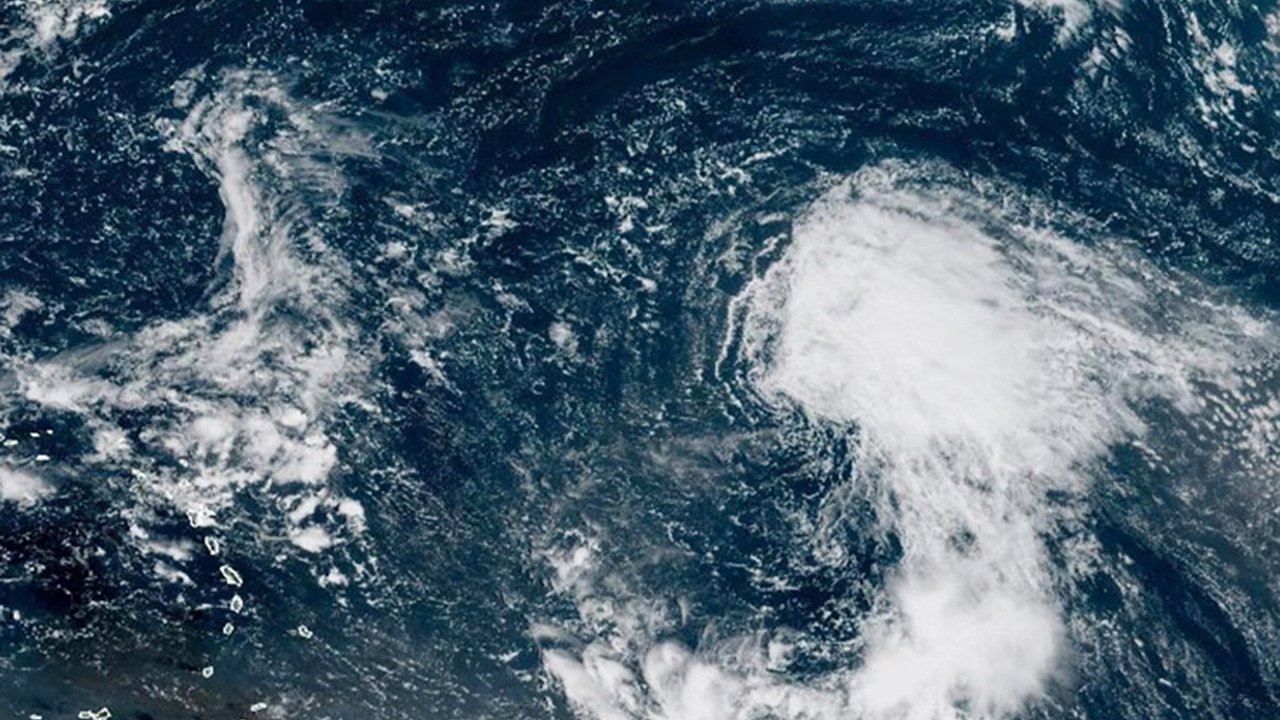
Tropical Storm Gabrielle emerged in the central Atlantic Ocean on Wednesday morning, becoming the latest named system in this year’s hurricane season. According to the National Hurricane Center and local meteorologists, Gabrielle is showing signs of steady organization and strengthening. Current forecasts indicate that the storm could intensify into a hurricane within the next several days.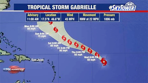 While tropical systems often spark concerns for residents along the Atlantic coast, meteorologists stress that Gabrielle is not expected to pose a threat to the United States. Instead, the storm will likely track northward into open waters, with only Bermuda having a slight chance of seeing impacts. Still, as with all tropical systems, forecasters remain cautious and continue to monitor its progress closely.Current position and storm detailsAs of 11 a.m. on Wednesday, Tropical Storm Gabrielle was located near latitude 17.5°N and longitude 46.6°W. That position places the system more than 1,000 miles east of the Northern Leeward Islands in the central Atlantic. At the time of the update, the storm carried maximum sustained winds of 45 miles per hour, with higher gusts possible.Gabrielle was moving north-northwest at 22 miles per hour, a fairly quick pace compared to other developing systems. Meteorologists note that the forward speed combined with favorable atmospheric conditions could contribute to steady strengthening over the next several days.Forecast path and intensity outlookMeteorologists expect Gabrielle to continue on its northward track, gradually intensifying as it moves across the Atlantic. Forecast models largely agree that the system will become a hurricane by the weekend. If this projection holds, Gabrielle will join the list of hurricanes that formed far from land and remained primarily a concern for shipping lanes and ocean activity.By early Monday morning, current models show Gabrielle well east of the United States coastline, curving northward into the open Atlantic. The storm is not expected to approach Florida or the southeastern U.S., which often see closer tropical threats during hurricane season.Possible impacts for BermudaWhile the majority of forecast models keep Gabrielle away from major landmasses, meteorologists say Bermuda could see some indirect effects depending on the exact track. FOX 13 Meteorologist Dave Osterberg explained that the island is the only location with even a slight chance of experiencing impacts from Gabrielle.
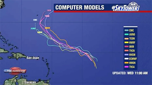 However, Bermuda sits in a region where storms often curve away before making landfall. Osterberg emphasized that it is historically rare for a hurricane to directly hit the island, though residents are accustomed to monitoring tropical systems that pass nearby. For now, the message for Bermuda remains one of watchful caution rather than alarm.Expert analysis from meteorologistsMeteorologists describe Gabrielle as a storm that will likely make headlines but not cause significant disruption. Osterberg noted, “This is going to be one of those storms that gets a name, but more than likely, isn’t going to bother anybody.” He added that the consistency among forecast models provides confidence that the storm will remain at sea.Even so, experts caution that tropical weather is inherently unpredictable, and shifts in track or strength can occur with little notice. That is why hurricane specialists continue to issue daily updates, ensuring that coastal residents, shipping operations, and island communities remain informed.The importance of monitoring Atlantic stormsEach named storm serves as a reminder of the importance of hurricane preparedness, even for regions not directly in a storm’s path. While Gabrielle is expected to stay far offshore, the system highlights how quickly tropical storms can form and strengthen during peak hurricane season.The Atlantic hurricane season runs from June 1 to November 30, with the most active period typically occurring between August and October. During this window, warm ocean waters and favorable atmospheric conditions create an environment where storms like Gabrielle can rapidly intensify.What residents should know moving forwardFor residents along the U.S. East Coast, Gabrielle poses no immediate concerns. However, it serves as a timely reminder to remain alert during hurricane season. Meteorologists encourage people to follow official updates from the National Hurricane Center and local weather services to stay informed.Bermuda residents should continue monitoring forecasts over the coming days, though the likelihood of significant impacts remains low. For now, Gabrielle is expected to strengthen over open waters before eventually curving north into the Atlantic, leaving most coastal regions unaffected.Tropical Storm Gabrielle’s development in the central Atlantic reinforces the unpredictability of hurricane season. While current forecasts suggest the storm will strengthen into a hurricane, its projected track indicates minimal threat to land. Bermuda may need to keep watch, but for the United States, Gabrielle is shaping up to be a system that stays at sea. Still, the storm underscores the importance of staying prepared and paying attention to forecasts, as conditions can change quickly.
While tropical systems often spark concerns for residents along the Atlantic coast, meteorologists stress that Gabrielle is not expected to pose a threat to the United States. Instead, the storm will likely track northward into open waters, with only Bermuda having a slight chance of seeing impacts. Still, as with all tropical systems, forecasters remain cautious and continue to monitor its progress closely.Current position and storm detailsAs of 11 a.m. on Wednesday, Tropical Storm Gabrielle was located near latitude 17.5°N and longitude 46.6°W. That position places the system more than 1,000 miles east of the Northern Leeward Islands in the central Atlantic. At the time of the update, the storm carried maximum sustained winds of 45 miles per hour, with higher gusts possible.Gabrielle was moving north-northwest at 22 miles per hour, a fairly quick pace compared to other developing systems. Meteorologists note that the forward speed combined with favorable atmospheric conditions could contribute to steady strengthening over the next several days.Forecast path and intensity outlookMeteorologists expect Gabrielle to continue on its northward track, gradually intensifying as it moves across the Atlantic. Forecast models largely agree that the system will become a hurricane by the weekend. If this projection holds, Gabrielle will join the list of hurricanes that formed far from land and remained primarily a concern for shipping lanes and ocean activity.By early Monday morning, current models show Gabrielle well east of the United States coastline, curving northward into the open Atlantic. The storm is not expected to approach Florida or the southeastern U.S., which often see closer tropical threats during hurricane season.Possible impacts for BermudaWhile the majority of forecast models keep Gabrielle away from major landmasses, meteorologists say Bermuda could see some indirect effects depending on the exact track. FOX 13 Meteorologist Dave Osterberg explained that the island is the only location with even a slight chance of experiencing impacts from Gabrielle.However, Bermuda sits in a region where storms often curve away before making landfall. Osterberg emphasized that it is historically rare for a hurricane to directly hit the island, though residents are accustomed to monitoring tropical systems that pass nearby. For now, the message for Bermuda remains one of watchful caution rather than alarm.Expert analysis from meteorologistsMeteorologists describe Gabrielle as a storm that will likely make headlines but not cause significant disruption. Osterberg noted, “This is going to be one of those storms that gets a name, but more than likely, isn’t going to bother anybody.” He added that the consistency among forecast models provides confidence that the storm will remain at sea.Even so, experts caution that tropical weather is inherently unpredictable, and shifts in track or strength can occur with little notice. That is why hurricane specialists continue to issue daily updates, ensuring that coastal residents, shipping operations, and island communities remain informed.The importance of monitoring Atlantic stormsEach named storm serves as a reminder of the importance of hurricane preparedness, even for regions not directly in a storm’s path. While Gabrielle is expected to stay far offshore, the system highlights how quickly tropical storms can form and strengthen during peak hurricane season.The Atlantic hurricane season runs from June 1 to November 30, with the most active period typically occurring between August and October. During this window, warm ocean waters and favorable atmospheric conditions create an environment where storms like Gabrielle can rapidly intensify.What residents should know moving forwardFor residents along the U.S. East Coast, Gabrielle poses no immediate concerns. However, it serves as a timely reminder to remain alert during hurricane season. Meteorologists encourage people to follow official updates from the National Hurricane Center and local weather services to stay informed.Bermuda residents should continue monitoring forecasts over the coming days, though the likelihood of significant impacts remains low. For now, Gabrielle is expected to strengthen over open waters before eventually curving north into the Atlantic, leaving most coastal regions unaffected.Tropical Storm Gabrielle’s development in the central Atlantic reinforces the unpredictability of hurricane season. While current forecasts suggest the storm will strengthen into a hurricane, its projected track indicates minimal threat to land. Bermuda may need to keep watch, but for the United States, Gabrielle is shaping up to be a system that stays at sea. Still, the storm underscores the importance of staying prepared and paying attention to forecasts, as conditions can change quickly.