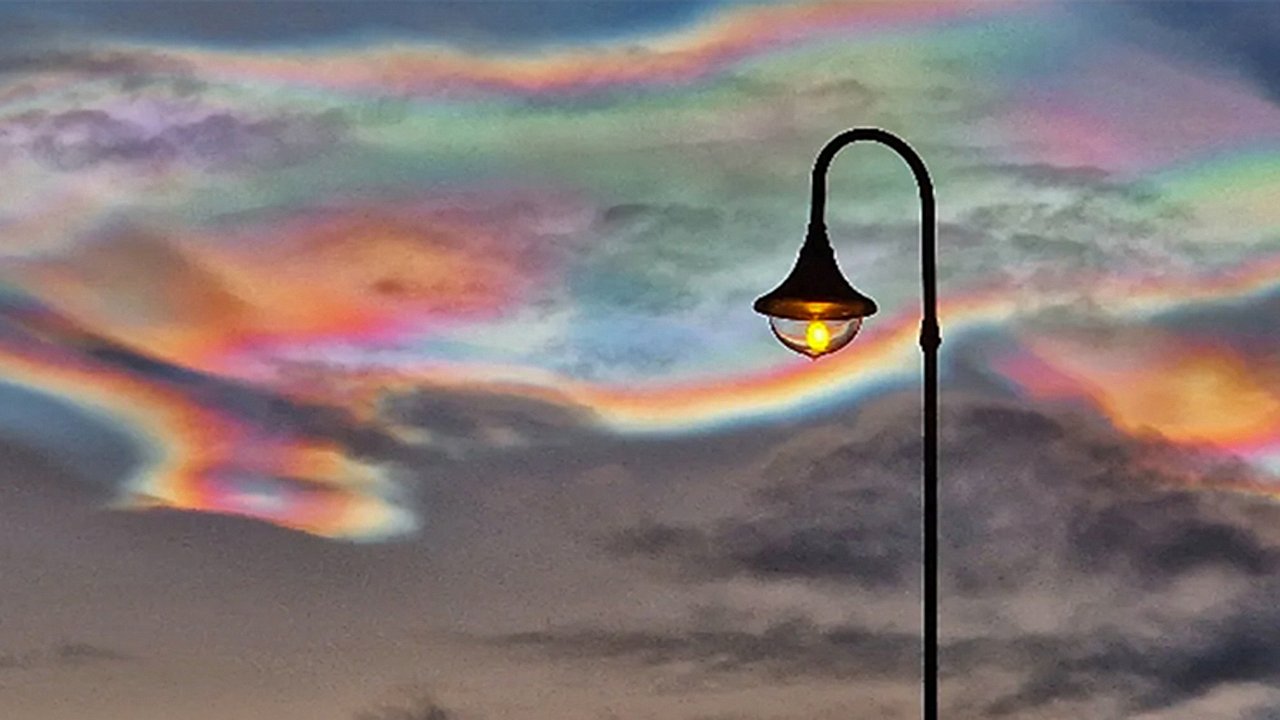
For three unforgettable days, the Arctic sky shimmered with surreal, rainbow-colored light as extremely rare polar stratospheric clouds appeared across northern landscapes. These breathtaking “rainbow clouds,” also known as nacreous clouds, were visible above Norway, Sweden, Finland, Alaska, and even parts of Scotland. Their vivid colors and shimmering, mother-of-pearl glow inspired awe among skywatchers and photographers, who captured some of the most striking atmospheric images of the year. But behind the beauty lies one of the most unusual and extreme meteorological events on Earth. These clouds only form when the stratosphere becomes exceptionally cold—far colder than what is needed for normal cloud formation. Their emergence for several consecutive days highlights just how rare the conditions must be for these spectacular displays to appear. This article explores how polar stratospheric clouds form, why they shine like rainbows, the science behind their recent outbreak, and what their presence may indicate about future atmospheric change.What makes rainbow clouds incredibly rare
Rainbow clouds, or polar stratospheric clouds (PSCs), only appear under extraordinarily specific atmospheric conditions. Unlike the clouds we see daily in the troposphere, PSCs form in the stratosphere, a region that is typically far too dry for cloud development. For PSCs to materialize, temperatures must drop below minus 121 degrees Fahrenheit or minus 85 degrees Celsius. These extreme temperatures allow widely spaced water molecules to freeze into tiny ice crystals at altitudes between 9.3 and 15.5 miles above Earth’s surface. Because such temperatures are uncommon even in polar regions, PSCs are considered extremely rare. Their appearance for three days in a row suggests an unusually prolonged cold snap in the upper atmosphere, making the recent event one of the most striking atmospheric occurrences of the season.How sunlight creates their iridescent colors
The dazzling hues of nacreous clouds come from a fascinating interaction between sunlight and ice crystals. When sunlight strikes the tiny crystals that make up these clouds, it refracts and scatters into separate wavelengths. This scattering effect splits the light into shimmering shades of pink, green, purple, gold, and blue, producing the rainbow-like appearance visible from the ground. The colors are brightest during sunrise and sunset, when the angle of sunlight enhances the refraction. Because PSCs sit so high in the stratosphere, sunlight can still reach them even when the sun has dipped below the horizon. This makes twilight the ideal moment to witness their full spectral brilliance. Many observers reported that the clouds glowed more intensely just before sunset, creating dramatic scenes that resemble the aurora but are formed through entirely different processes.Where the rare Arctic outbreak occurred
The December outbreak of rainbow clouds extended across much of the Arctic and even into northern Europe. PSCs were clearly visible between December 18 and December 20, with faint remnants still apparent on December 21. Sightings were reported in Norway, Sweden, Finland, Alaska, and Scotland, marking one of the largest and most widespread PSC events seen in recent years. Photographer Ramunė Šapailaitė captured particularly stunning images above Gran in southern Norway, where the colors intensified across the sky. Her photographs showcased the signature mother-of-pearl shimmer that gives nacreous clouds their name. The widespread visibility of the clouds reflected unusually cold stratospheric air across a broad region, highlighting just how extensive the atmospheric anomaly was.The difference between Type I and Type II clouds
There are two primary types of polar stratospheric clouds, each formed under different chemical and temperature conditions. Type I PSCs consist of a mix of water and nitric acid. They tend to produce muted colors and play a significant role in ozone depletion by enabling chemical reactions that break down the ozone layer.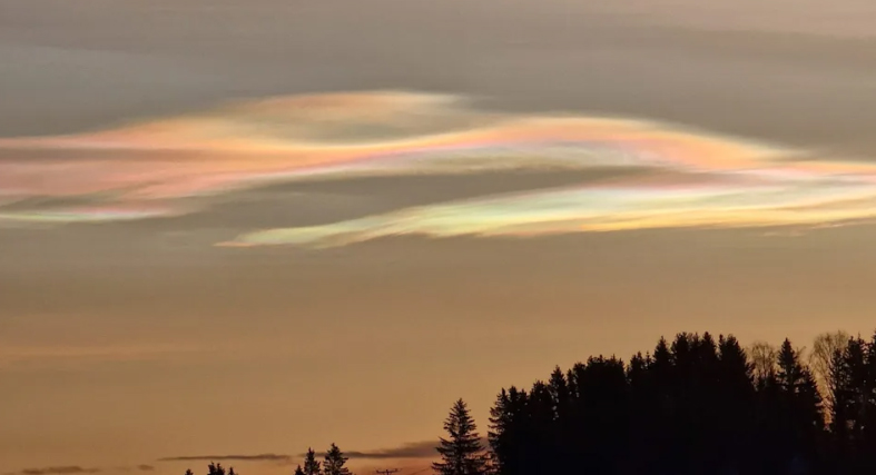 Type II PSCs, on the other hand, form exclusively from pure ice crystals when temperatures drop even lower than those required for Type I. These pure ice clouds create much more vivid, iridescent colors and are far rarer. The Arctic outbreak consisted predominantly of Type II clouds, which explains the intensity and vibrancy of the rainbow hues observed. Their appearance signals exceptionally cold stratospheric temperatures, making them valuable indicators for atmospheric researchers.How extreme cold triggers PSC formation
The key ingredient behind polar stratospheric clouds is intense, prolonged cold. For ice crystals to form at stratospheric altitudes, temperatures must fall well below what is typical for polar winter. When this happens, the sparse water vapor present in the stratosphere can freeze into microscopic crystals that cluster together and form PSCs. During the December event, upper-atmosphere temperatures remained below the extremely low threshold for several consecutive days. This allowed the clouds not only to form but also to persist—an unusual occurrence considering how quickly stratospheric temperatures can fluctuate. The extended cold period is what made the three-day display possible, and it may indicate broader shifts in atmospheric patterns linked to polar climate variability.Climate implications and future visibility
Scientists believe that polar stratospheric clouds may become more common as climate patterns shift. Paradoxically, while the Earth’s surface is warming, changes in air circulation and moisture content may contribute to colder spells in the upper atmosphere. If these conditions occur more frequently, PSC sightings may increase. However, a rise in Type I PSCs could have negative consequences for the ozone layer, as these clouds facilitate ozone-depleting reactions. This makes monitoring PSC trends essential for understanding long-term atmospheric health. For skywatchers, increased PSC activity could mean more opportunities to witness these mesmerizing displays, but for scientists, they represent important clues about evolving climate dynamics.Why rainbow clouds are often mistaken for auroras
Many people who encounter PSCs for the first time assume they are seeing the aurora borealis. While both produce vibrant colors, their origins are completely different. Auroras form when charged particles from the sun interact with Earth’s magnetosphere, producing moving curtains of light. PSCs, by contrast, are stationary or gently shifting and owe their colors purely to sunlight refracting through ice crystals. Their pearl-like glow and static appearance set them apart once observers know what to look for. Understanding these differences enhances appreciation for both phenomena and helps observers identify which spectacle they are witnessing.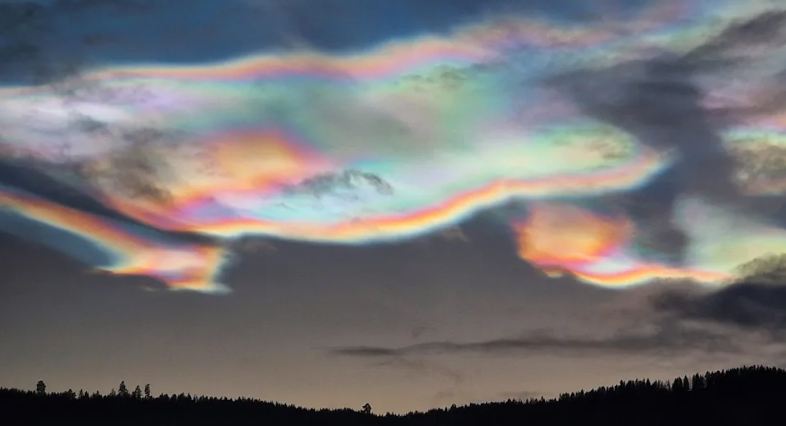 The three-day outburst of rainbow clouds across the Arctic was a breathtaking reminder of the rare beauty hidden within Earth’s atmosphere. These nacreous clouds, formed under extreme stratospheric cold, delivered a spectacle that captivated skywatchers and scientists alike. Their shimmering colors and unusual persistence made this event one of the most memorable atmospheric displays of the year.
But behind the beauty lies one of the most unusual and extreme meteorological events on Earth. These clouds only form when the stratosphere becomes exceptionally cold—far colder than what is needed for normal cloud formation. Their emergence for several consecutive days highlights just how rare the conditions must be for these spectacular displays to appear. This article explores how polar stratospheric clouds form, why they shine like rainbows, the science behind their recent outbreak, and what their presence may indicate about future atmospheric change.What makes rainbow clouds incredibly rareRainbow clouds, or polar stratospheric clouds (PSCs), only appear under extraordinarily specific atmospheric conditions. Unlike the clouds we see daily in the troposphere, PSCs form in the stratosphere, a region that is typically far too dry for cloud development. For PSCs to materialize, temperatures must drop below minus 121 degrees Fahrenheit or minus 85 degrees Celsius. These extreme temperatures allow widely spaced water molecules to freeze into tiny ice crystals at altitudes between 9.3 and 15.5 miles above Earth’s surface. Because such temperatures are uncommon even in polar regions, PSCs are considered extremely rare. Their appearance for three days in a row suggests an unusually prolonged cold snap in the upper atmosphere, making the recent event one of the most striking atmospheric occurrences of the season.How sunlight creates their iridescent colors
The dazzling hues of nacreous clouds come from a fascinating interaction between sunlight and ice crystals. When sunlight strikes the tiny crystals that make up these clouds, it refracts and scatters into separate wavelengths. This scattering effect splits the light into shimmering shades of pink, green, purple, gold, and blue, producing the rainbow-like appearance visible from the ground.
The colors are brightest during sunrise and sunset, when the angle of sunlight enhances the refraction. Because PSCs sit so high in the stratosphere, sunlight can still reach them even when the sun has dipped below the horizon. This makes twilight the ideal moment to witness their full spectral brilliance. Many observers reported that the clouds glowed more intensely just before sunset, creating dramatic scenes that resemble the aurora but are formed through entirely different processes.Where the rare Arctic outbreak occurredThe December outbreak of rainbow clouds extended across much of the Arctic and even into northern Europe. PSCs were clearly visible between December 18 and December 20, with faint remnants still apparent on December 21. Sightings were reported in Norway, Sweden, Finland, Alaska, and Scotland, marking one of the largest and most widespread PSC events seen in recent years. Photographer Ramunė Šapailaitė captured particularly stunning images above Gran in southern Norway, where the colors intensified across the sky. Her photographs showcased the signature mother-of-pearl shimmer that gives nacreous clouds their name. The widespread visibility of the clouds reflected unusually cold stratospheric air across a broad region, highlighting just how extensive the atmospheric anomaly was.The difference between Type I and Type II clouds
There are two primary types of polar stratospheric clouds, each formed under different chemical and temperature conditions. Type I PSCs consist of a mix of water and nitric acid. They tend to produce muted colors and play a significant role in ozone depletion by enabling chemical reactions that break down the ozone layer.
Type II PSCs, on the other hand, form exclusively from pure ice crystals when temperatures drop even lower than those required for Type I. These pure ice clouds create much more vivid, iridescent colors and are far rarer. The Arctic outbreak consisted predominantly of Type II clouds, which explains the intensity and vibrancy of the rainbow hues observed. Their appearance signals exceptionally cold stratospheric temperatures, making them valuable indicators for atmospheric researchers.How extreme cold triggers PSC formationThe key ingredient behind polar stratospheric clouds is intense, prolonged cold. For ice crystals to form at stratospheric altitudes, temperatures must fall well below what is typical for polar winter. When this happens, the sparse water vapor present in the stratosphere can freeze into microscopic crystals that cluster together and form PSCs. During the December event, upper-atmosphere temperatures remained below the extremely low threshold for several consecutive days. This allowed the clouds not only to form but also to persist—an unusual occurrence considering how quickly stratospheric temperatures can fluctuate. The extended cold period is what made the three-day display possible, and it may indicate broader shifts in atmospheric patterns linked to polar climate variability.Climate implications and future visibility
Scientists believe that polar stratospheric clouds may become more common as climate patterns shift. Paradoxically, while the Earth’s surface is warming, changes in air circulation and moisture content may contribute to colder spells in the upper atmosphere. If these conditions occur more frequently, PSC sightings may increase. However, a rise in Type I PSCs could have negative consequences for the ozone layer, as these clouds facilitate ozone-depleting reactions. This makes monitoring PSC trends essential for understanding long-term atmospheric health. For skywatchers, increased PSC activity could mean more opportunities to witness these mesmerizing displays, but for scientists, they represent important clues about evolving climate dynamics.Why rainbow clouds are often mistaken for auroras
Many people who encounter PSCs for the first time assume they are seeing the aurora borealis. While both produce vibrant colors, their origins are completely different. Auroras form when charged particles from the sun interact with Earth’s magnetosphere, producing moving curtains of light. PSCs, by contrast, are stationary or gently shifting and owe their colors purely to sunlight refracting through ice crystals. Their pearl-like glow and static appearance set them apart once observers know what to look for. Understanding these differences enhances appreciation for both phenomena and helps observers identify which spectacle they are witnessing.
The three-day outburst of rainbow clouds across the Arctic was a breathtaking reminder of the rare beauty hidden within Earth’s atmosphere. These nacreous clouds, formed under extreme stratospheric cold, delivered a spectacle that captivated skywatchers and scientists alike. Their shimmering colors and unusual persistence made this event one of the most memorable atmospheric displays of the year.