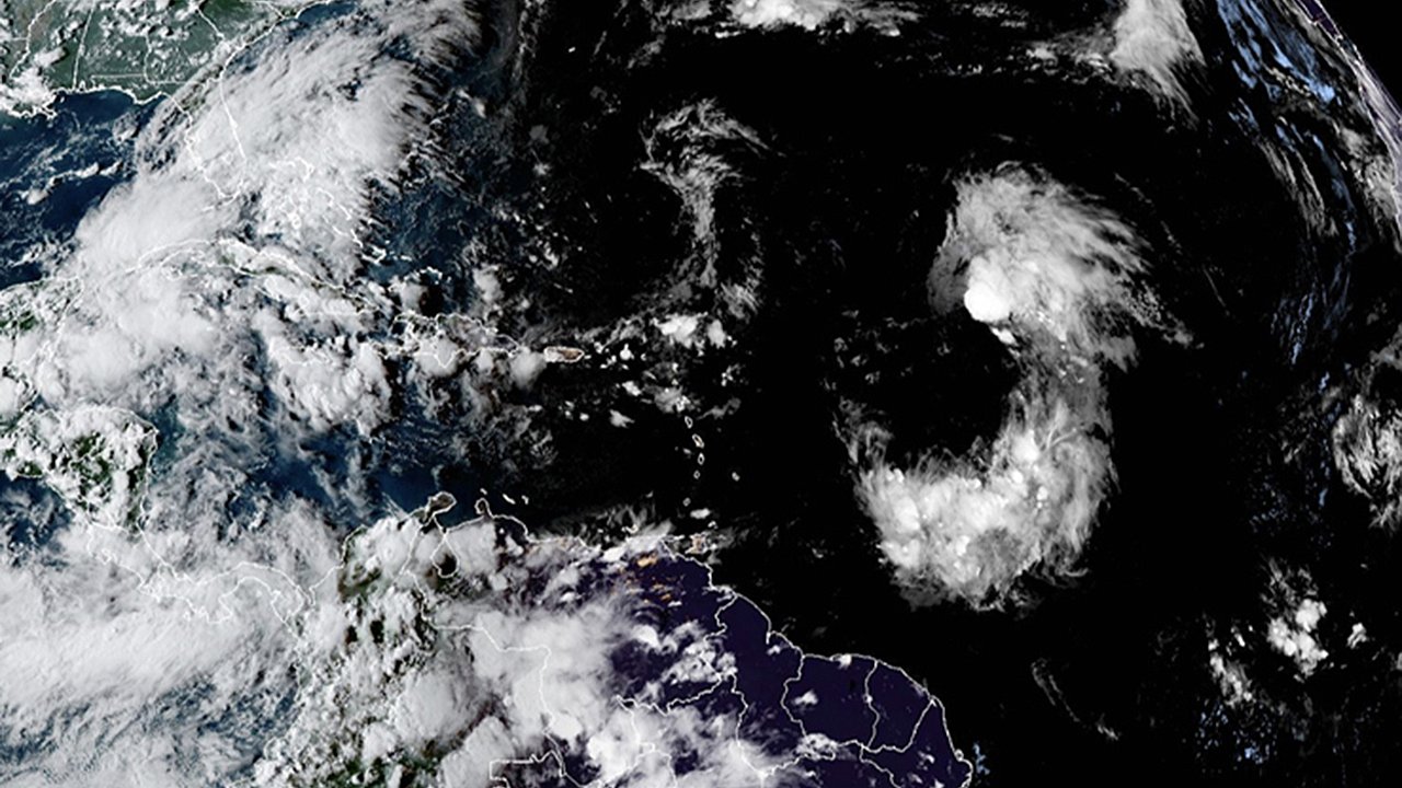
The threat of dangerous flash flooding is not over for the Desert Southwest, even after a week of destructive storms that washed out roads and claimed lives. Meteorologists warn that another wave of monsoonal moisture will bring renewed flood concerns to southern California, Arizona, and New Mexico starting Sunday. Burn scar areas are particularly vulnerable, where even minimal rainfall can quickly lead to debris flows and mudslides.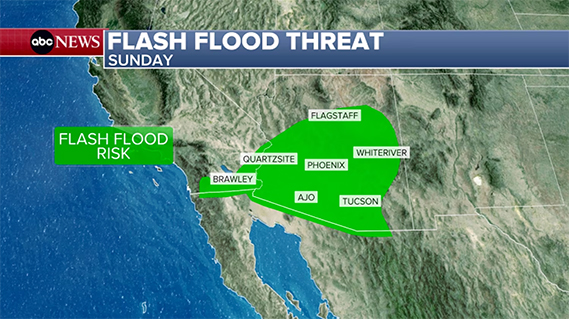 While the West braces for more unsettled weather, attention also turns to the Atlantic. Tropical Storm Gabrielle, currently churning in the central Atlantic Ocean, is expected to strengthen into a hurricane by late Sunday. Though it poses no direct threat to land, Gabrielle highlights the increasing activity of the 2025 Atlantic hurricane season, which runs through the end of November. At the same time, forecasters are monitoring another tropical wave off the African coast, adding to concerns about a potentially active stretch of storm development.Flash flooding concerns shift back to the Desert SouthwestAfter a brief lull on Saturday, a renewed push of tropical moisture will reintroduce flash flooding risks across the Southwest. The National Weather Service has issued a Level 1 of 4 risk for excessive rainfall beginning Sunday.
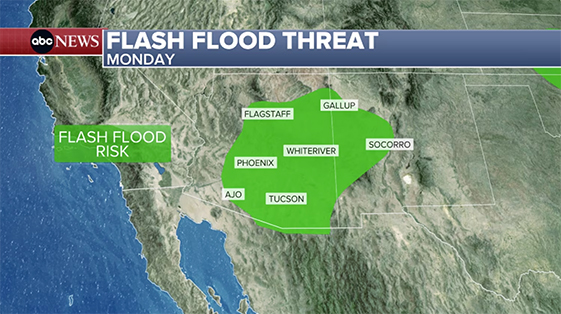 Southern California and Arizona could see isolated thunderstorms and downpours, producing localized flooding in normally dry washes and low-lying areas. By Monday, the focus of the flood risk moves eastward into New Mexico.Communities near recent wildfires face the greatest danger. Burn scars drastically reduce the soil’s ability to absorb water, making these regions especially prone to flash flooding, debris flows, and mudslides. Even modest rainfall amounts can trigger life-threatening hazards in these zones.Recent storms leave deadly impact in CaliforniaThe renewed flood threat comes on the heels of devastating storms earlier in the week. In Barstow, California, tragedy struck when floodwaters swept away a family’s car. After more than 20 hours of intensive search and rescue efforts, authorities confirmed the recovery of a 2-year-old child who had been carried away by the rushing waters.
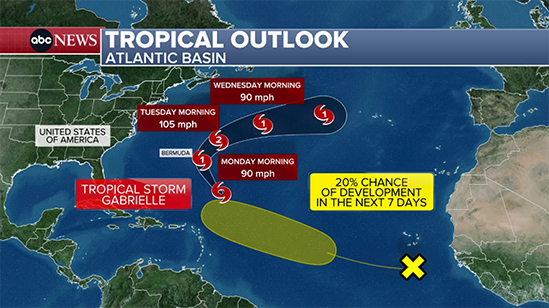 Elsewhere across the region, intense downpours dropped 1 to 2 inches of rain within an hour, overwhelming drainage systems and washing out roadways. Vehicles, property, and infrastructure caught in the path of these flash floods suffered significant damage, underscoring the sudden and destructive nature of desert flooding.Tropical Storm Gabrielle continues to intensifyFar from the U.S. mainland, Tropical Storm Gabrielle is battling unfavorable atmospheric conditions, including wind shear and dry air. Despite these challenges, the storm has slowly organized and is expected to encounter warmer waters and reduced shear over the next 24 hours.
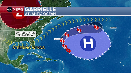 Forecasters anticipate Gabrielle could strengthen into the second hurricane of the 2025 Atlantic season by late Sunday. Historically, the second hurricane typically forms by late August, meaning this development is nearly a month behind average seasonal patterns.Gabrielle is projected to remain well offshore, staying east of Bermuda before curving northeast into the open Atlantic next week. While it poses no immediate threat to land, the storm will be closely monitored by hurricane hunter aircraft, which are scheduled to collect critical data on its structure and intensity.Atlantic hurricane season shows signs of awakeningBeyond Gabrielle, the National Hurricane Center is tracking a tropical wave off the west coast of Africa. Although currently disorganized, it has a 20% chance of development within the next week as it moves westward across the central Atlantic.
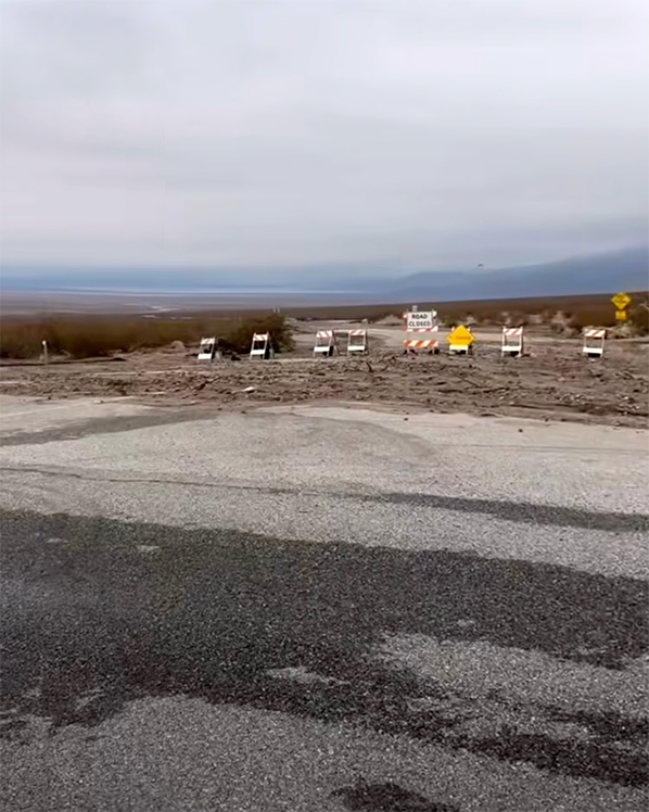 If it strengthens, the system would likely follow a path similar to Gabrielle, steering away from land but contributing to the uptick in Atlantic activity. Meteorologists expect tropical development to gradually increase over the next several weeks as conditions in the Atlantic basin become more favorable.The 2025 Atlantic hurricane season, which began June 1 and runs through November 30, has been relatively quiet so far. However, with warm ocean waters and improving atmospheric conditions, experts warn that the peak of the season could still bring multiple hurricanes and storms worth monitoring.Looking ahead for the Southwest and AtlanticFor much of the Desert Southwest, conditions are forecast to turn dry and calm by the middle of next week. This will provide some relief following a period of destructive storms. However, the short-term flood risk remains significant through Monday, particularly for vulnerable burn scar areas.
 In the Atlantic, Gabrielle’s progress will dominate tropical weather discussions. Though it is unlikely to pose a direct land threat, its potential strengthening into a hurricane serves as a reminder that the heart of hurricane season has arrived. Communities across the U.S. East Coast and Gulf Coast are urged to stay alert, as additional storms may emerge in the coming weeks.
While the West braces for more unsettled weather, attention also turns to the Atlantic. Tropical Storm Gabrielle, currently churning in the central Atlantic Ocean, is expected to strengthen into a hurricane by late Sunday. Though it poses no direct threat to land, Gabrielle highlights the increasing activity of the 2025 Atlantic hurricane season, which runs through the end of November. At the same time, forecasters are monitoring another tropical wave off the African coast, adding to concerns about a potentially active stretch of storm development.Flash flooding concerns shift back to the Desert SouthwestAfter a brief lull on Saturday, a renewed push of tropical moisture will reintroduce flash flooding risks across the Southwest. The National Weather Service has issued a Level 1 of 4 risk for excessive rainfall beginning Sunday.Southern California and Arizona could see isolated thunderstorms and downpours, producing localized flooding in normally dry washes and low-lying areas. By Monday, the focus of the flood risk moves eastward into New Mexico.Communities near recent wildfires face the greatest danger. Burn scars drastically reduce the soil’s ability to absorb water, making these regions especially prone to flash flooding, debris flows, and mudslides. Even modest rainfall amounts can trigger life-threatening hazards in these zones.Recent storms leave deadly impact in CaliforniaThe renewed flood threat comes on the heels of devastating storms earlier in the week. In Barstow, California, tragedy struck when floodwaters swept away a family’s car. After more than 20 hours of intensive search and rescue efforts, authorities confirmed the recovery of a 2-year-old child who had been carried away by the rushing waters.Elsewhere across the region, intense downpours dropped 1 to 2 inches of rain within an hour, overwhelming drainage systems and washing out roadways. Vehicles, property, and infrastructure caught in the path of these flash floods suffered significant damage, underscoring the sudden and destructive nature of desert flooding.Tropical Storm Gabrielle continues to intensifyFar from the U.S. mainland, Tropical Storm Gabrielle is battling unfavorable atmospheric conditions, including wind shear and dry air. Despite these challenges, the storm has slowly organized and is expected to encounter warmer waters and reduced shear over the next 24 hours.Forecasters anticipate Gabrielle could strengthen into the second hurricane of the 2025 Atlantic season by late Sunday. Historically, the second hurricane typically forms by late August, meaning this development is nearly a month behind average seasonal patterns.Gabrielle is projected to remain well offshore, staying east of Bermuda before curving northeast into the open Atlantic next week. While it poses no immediate threat to land, the storm will be closely monitored by hurricane hunter aircraft, which are scheduled to collect critical data on its structure and intensity.Atlantic hurricane season shows signs of awakeningBeyond Gabrielle, the National Hurricane Center is tracking a tropical wave off the west coast of Africa. Although currently disorganized, it has a 20% chance of development within the next week as it moves westward across the central Atlantic.If it strengthens, the system would likely follow a path similar to Gabrielle, steering away from land but contributing to the uptick in Atlantic activity. Meteorologists expect tropical development to gradually increase over the next several weeks as conditions in the Atlantic basin become more favorable.The 2025 Atlantic hurricane season, which began June 1 and runs through November 30, has been relatively quiet so far. However, with warm ocean waters and improving atmospheric conditions, experts warn that the peak of the season could still bring multiple hurricanes and storms worth monitoring.Looking ahead for the Southwest and AtlanticFor much of the Desert Southwest, conditions are forecast to turn dry and calm by the middle of next week. This will provide some relief following a period of destructive storms. However, the short-term flood risk remains significant through Monday, particularly for vulnerable burn scar areas.In the Atlantic, Gabrielle’s progress will dominate tropical weather discussions. Though it is unlikely to pose a direct land threat, its potential strengthening into a hurricane serves as a reminder that the heart of hurricane season has arrived. Communities across the U.S. East Coast and Gulf Coast are urged to stay alert, as additional storms may emerge in the coming weeks.